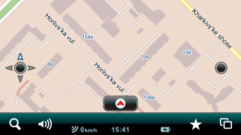
Coverage between cities
Coverage between cities includes paved roads between settlements as well as a large number of unpaved roads,
railways, forests, rivers, lakes and seas:
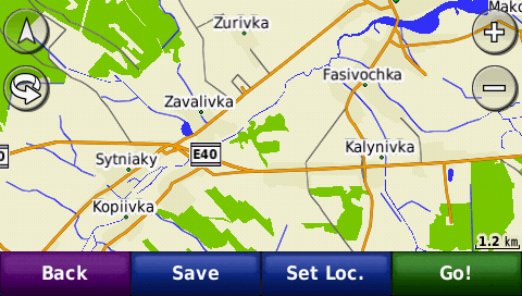
The map also contains a large number of road junctions, both in the settlements and between them:
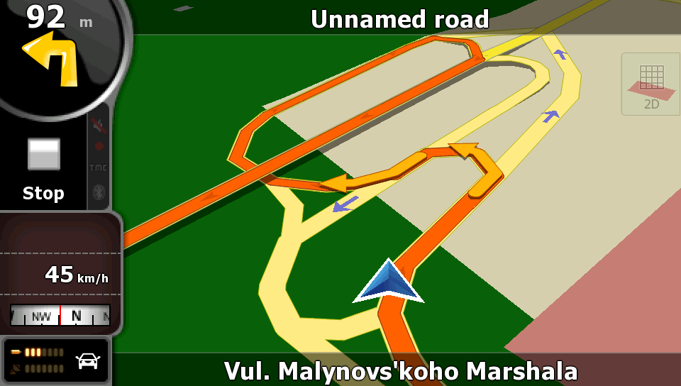
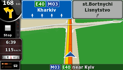
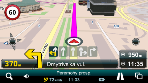
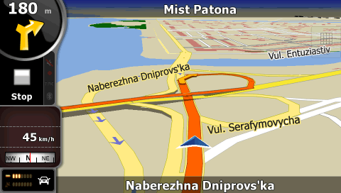
Signposts with lane information are provided on the Kyiv–Boryspil’ highway:
Coverage of settlements and address search
Detailed coverage is available for the settlements in which live more than
53.7% of the Ukrainian population, including, in particular, all regional centers, all cities with more than
40 000 inhabitants. Most of this coverage contain building footprints with house numbers as well:
The map contains intrablock driveways in many cities; accuracy of this coverage in Kyiv, Kharkiv, Dnipropetrovs'k, Donets'k and Zaporizhzhia is
unique:
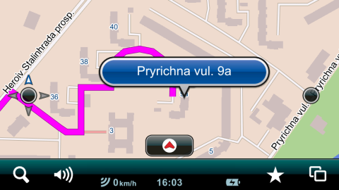
The map supports point address search and house numbers containing letters or slashes, and may route right to the building.
A large number of smaller settlements have street network coverage without street naming and address search:
Automatic route calculation
The navigation device automatically calculates an optimal route from the user’s location to a chosen place, and warns the user
about the following maneuver beforehand while driving.
Depending on the device model, route optimization by time or distance and setting avoidances (such as avoidance of U-turns, unpaved
roads etc.) as well as calculation of complex routes are usually possible.
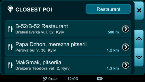
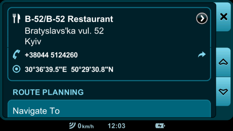
Points of Interest (POIs)
The map contains about 82 760 Points of Interest (POIs). They are, in the first place, fuel and service
stations, restaurants, hotels, banks and cash dispensers, airports, railway and bus stations, subway stations, wharves, border
crossing points, historical sites, churches, theatres, cinemas, pharmacies, hospitals, state institutions etc. A lot of POIs contain
contact information (phone number, postcode, address, email address and website), depending on the device model, it may be possible
not only to calculate a route to the point, but to call there immediately, go to the website or send an email letter as well.
Versions History
2016.06
Changes made compared to 2015.03
- The total road network coverage is increased by 1 000 km and constitutes
477 000 km.
- Renamed over 900 settlements as well as over 1 000 street names due to the implementation of the decommunization law all over the country.
- Detailed coverage is added for 6 settlements, namely:
- Khmelnyts'ka oblast':
Muksha Kytaihorods'ka (Zhovtneve),
Slobidka-Humenets'ka.
- Odes'ka oblast':
Artsyz,
Bolhrad.
- Poltavs'ka oblast':
Hadiach.
- Zakarpats'ka oblast':
Chop.
- The total street network coverage is increased by 0.1% and now constitutes 53.7% by population.
Address search covers 46.9% by population.
- Street network and address database of the cities of Kirovohrad and Kam'ianets'-Podil's'kyi are substantially updated.
- Number of POIs is increased to about 82 760.
- A large number of feedback messages are processed.
Specification
- Automatic route calculation with regard to Traffic regulations
- Total length of the road network: 477 000 km
- Over 30 000 settlements
- Detailed coverage of settlements: 53.7% of the Ukrainian population,
or 942 settlements, including 186 cities, in particular:
- all regional centers
- all cities with more than 40 000 inhabitants
- Almost all detailed coverage (46.9% of population) includes address search
- Building footprints with house numbers: 43.7% of population
- 3D buildings (elevated footprints): 25% of population
- 3D landmarks: 59, including National Opera of Ukraine, Kyiv National University, stadiums such as NSC Olimpiys'kyi (Kyiv), Donbas Arena (Donets'k), Arena L'viv and Metalist (Kharkiv).
- Detailed coverage of all settlements in 11 districts of Kyiv region such as: Bilotserkivs'kyi, Borodians'kyi, Boryspil's'kyi, Brovars'kyi, Kaharlyts'kyi,
Kyievo-Sviatoshyns'kyi, Makarivs'kyi, Obukhivs'kyi, Pereiaslav-Kmel'nyts’kyi, Vasyl'kivs'kyi and Vyshhorods'kyi
- Intrablock driveways in many cities, uniquely accurate in Kyiv, Kharkiv, Dnipropetrovs'k, Donets'k and Zaporizhzhia
- Time dependent driving restrictions
- Lane & Signpost Information – available for the city of Kyiv as well as for Kyiv–Boryspil’ highway
- Basic coverage of the road network without street naming and address search: most settlements with more than 5 000
inhabitants
- A large number of grade-separated intersections
- A large number of unpaved roads
- Number of POIs: about 82 760, most of them contain contact information
- Railways, forests, parks, rivers, streams, channels, lakes and seas
- Languages: Ukrainian, English and Russian
- Updates are issued on a trimestrial basis
2015.03
Changes made compared to 2014.09
- The total road network coverage is increased by 400 km and constitutes
476 000 km.
- Detailed coverage is added for 3 settlements, namely:
- Odes'ka oblast':
Balta,
Kiliia,
Rozdil'na.
- The total street network coverage is increased by 0.2% and now constitutes 53.6% by population.
Address search covers 46.9% by population.
- Building footprints added for 1 settlement:
- Dnipropetrovs'ka oblast':
Nikopol'.
- Building elevations (3D) added for 1 settlement:
- Dnipropetrovs'ka oblast':
Nikopol'.
- The network of international, regional and territorial roads in Ivano-Frankivs'ka oblast', Odes'ka oblast', Zakarpats'ka oblast' and Zhytomyrs'ka oblast' has been updated.
- Number of POIs is increased to about 82 700.
- A large number of feedback messages are processed.
Changes made compared to 2014.03
- The total road network coverage is increased by 2 700 km and constitutes
476 000 km.
- Detailed coverage is added for 13 settlements, namely:
- Avtonomna Respublika Krym:
Dzhankoi,
Zaozerne,
Dmytrivka,
Michurinivka;
- Ivano-Frankivs’ka oblast':
Dolyna,
Novychka;
- Khmel'nyts'ka oblast':
Netishyn;
- Odes'ka oblast':
Balta,
Kiliia,
Kotovs'k,
Rozdil'na,
Vesternychany,
Kuial'nyk.
- The total street network coverage is increased by 0.4% and now constitutes 53.6% by population.
Address search covers 46.9% by population.
- Building footprints added for 5 settlements:
- Avtonomna Respublika Krym:
Dzhankoi,
Yevpatoriia,
Dmytrivka,
Michurinivka;
- Dnipropetrovs'ka oblast':
Nikopol'.
- Building elevations (3D) added for 4 settlements:
- Avtonomna Respublika Krym:
Dzhankoi,
Dmytrivka,
Michurinivka;
- Dnipropetrovs'ka oblast':
Nikopol'.
- The network of international, regional and territorial roads in Ivano-Frankivs'ka oblast', Odes'ka oblast', Zakarpats'ka oblast' and Zhytomyrs'ka oblast' has been updated.
- Number of POIs is increased to about 82 700.
- A large number of feedback messages are processed.
Specification
- Automatic route calculation with regard to Traffic regulations
- Total length of road coverage: 476 000 km
- Over 30 000 settlements
- Detailed coverage of settlements: 53.6% of the Ukrainian population,
or 931 settlements, including 182 cities, in particular,
all regional centers and all cities with more than 40 000 inhabitants;
almost all of this coverage (46.9% of population) includes address search
- Building footprints and building numbers: 43.7% of population
- 3D buildings (elevated footprints): 25% of population
- Detailed coverage of all settlements in Bilotserkivs'kyi, Borodians'kyi, Boryspil's'kyi, Brovars'kyi, Kaharlyts'kyi,
Kyievo-Sviatoshyns'kyi, Makarivs'kyi, Obukhivs'kyi, Pereiaslav-Kmel'nyts’kyi, Vasyl'kivs'kyi and Vyshhorods'kyi raions (Districts)
of Kyivs'ka oblast' (Region)
- In-block passages in many cities, uniquely accurate in Kyiv, Kharkiv, Dnipropetrovs'k, Donets'k and Zaporizhzhia
- Time dependent driving restrictions
- Lane Information – available for Kyiv–Boryspil’ highway and for a number of intersections in Kyiv
- Signpost information – available for Kyiv–Boryspil’ highway
- Basic coverage of the road network without street naming and address search: most settlements with more than 5 000
inhabitants
- A large number of grade-separated intersections
- A large number of unpaved roads
- Number of POIs: about 82 700, most of them contain contact information
- Railways, forests, parks, rivers, streams, channels, lakes and seas
- Languages: Ukrainian, English and Russian
- Updates are issued on a trimestrial basis
2014.12
Changes made compared to 2014.09
- The total road network coverage is increased by 200 km and constitutes
475 800 km.
- Detailed coverage is added for 2 settlements, namely:
- Ivano-Frankivs’ka oblast':
Dolyna,
Novychka.
- The total street network coverage is increased by 0.1% and now constitutes 53.5% by population.
Address search covers 46.6% by population.
- The network of international, regional and territorial roads in Ivano-Frankivs'ka oblast', Zakarpats'ka oblast' and Zhytomyrs'ka oblast' has been updated.
- Number of POIs is increased to about 82 690.
- A large number of feedback messages are processed.
Changes made compared to 2014.03
- The total road network coverage is increased by 2 500 km and constitutes
475 800 km.
- Detailed coverage is added for 10 settlements, namely:
- Avtonomna Respublika Krym:
Dzhankoi,
Zaozerne,
Dmytrivka,
Michurinivka;
- Ivano-Frankivs’ka oblast':
Dolyna,
Novychka;
- Khmel'nyts'ka oblast':
Netishyn;
- Odes'ka oblast':
Kotovs'k,
Vesternychany,
Kuial'nyk.
- The total street network coverage is increased by 0.3% and now constitutes 53.5% by population.
Address search covers 46.6% by population.
- Building footprints added for 4 settlements:
- Avtonomna Respublika Krym:
Dzhankoi,
Yevpatoriia,
Dmytrivka,
Michurinivka.
- Building elevations (3D) added for 3 settlements:
- Avtonomna Respublika Krym:
Dzhankoi,
Dmytrivka,
Michurinivka.
- The network of international, regional and territorial roads in Zhytomyrs'ka oblast', Zakarpats'ka oblast' and Ivano-Frankivs'ka oblast' has been updated.
- Number of POIs is increased to about 82 690.
- A large number of feedback messages are processed.
Specification
- Automatic route calculation with regard to Traffic regulations
- Total length of road coverage: 475 800 km
- Over 30 000 settlements
- Detailed coverage of settlements: 53.5% of the Ukrainian population,
or 931 settlements, including 179 cities, in particular,
all regional centers and all cities with more than 40 000 inhabitants;
almost all of this coverage (46.6% of population) includes address search
- Building footprints and building numbers: 43.4% of population
- 3D buildings (elevated footprints): 24.7% of population
- Detailed coverage of all settlements in Bilotserkivs'kyi, Borodians'kyi, Boryspil's'kyi, Brovars'kyi, Kaharlyts'kyi,
Kyievo-Sviatoshyns'kyi, Makarivs'kyi, Obukhivs'kyi, Pereiaslav-Kmel'nyts’kyi, Vasyl'kivs'kyi and Vyshhorods'kyi raions (Districts)
of Kyivs'ka oblast' (Region)
- In-block passages in many cities, uniquely accurate in Kyiv, Kharkiv, Dnipropetrovs'k, Donets'k and Zaporizhzhia
- Time dependent driving restrictions
- Lane Information – available for Kyiv–Boryspil’ highway and for a number of intersections in Kyiv
- Signpost information – available for Kyiv–Boryspil’ highway
- Basic coverage of the road network without street naming and address search: most settlements with more than 5 000
inhabitants
- A large number of grade-separated intersections
- A large number of unpaved roads
- Number of POIs: about 82 690, a lot of them contain contact information
- Railways, forests, parks, rivers, streams, channels, lakes and seas
- Languages: Ukrainian, English and Russian
- Updates are issued on a trimestrial basis
2014.09
Changes made compared to 2014.03
- The total road network coverage is increased by 2 300 km and constitutes
475 600 km.
- Detailed coverage is added for 8 settlements, namely:
- Avtonomna Respublika Krym:
Dzhankoi,
Zaozerne,
Dmytrivka,
Michurinivka;
- Khmel'nyts'ka oblast':
Netishyn;
- Odes'ka oblast':
Kotovs'k,
Vesternychany,
Kuial'nyk.
- The total street network coverage is increased by 0.2% and now constitutes 53.4% by population.
Address search covers 46.6% by population.
- Building footprints added for 4 settlements:
- Avtonomna Respublika Krym:
Dzhankoi,
Yevpatoriia,
Dmytrivka,
Michurinivka;
- Building elevations (3D) added for 3 settlements:
- Avtonomna Respublika Krym:
Dzhankoi,
Dmytrivka,
Michurinivka;
- Number of POIs is increased to about 82 670.
- A large number of feedback messages are processed.
Changes made compared to 2013.12
- The total road network coverage is increased by 3 000 km and constitutes
475 600 km.
- Detailed coverage is added for 13 settlements, namely:
- Avtonomna Respublika Krym:
Dzhankoi,
Zaozerne,
Dmytrivka,
Michurinivka;
- Dnipropetrovs'ka oblast':
Ordzhonikidze,
Chortomlyk;
- Khmel'nyts'ka oblast':
Netishyn;
- Mykolaivs'ka oblast':
Yuzhnoukrains'k,
Kostiantynivka;
- Odes'ka oblast':
Kotovs'k,
Vesternychany,
Kuial'nyk;
- Rivnens'ka oblast':
Kuznetsovs'k.
- The total street network coverage is increased by 0.5% and now constitutes 53.4% by population.
Address search covers 46.6% by population.
- Building footprints added for 7 settlements:
- Avtonomna Respublika Krym:
Dzhankoi,
Yevpatoriia,
Dmytrivka,
Michurinivka;
- Mykolaivs'ka oblast':
Yuzhnoukrains'k,
Kostiantynivka;
- Rivnens'ka oblast':
Kuznetsovs'k.
- Building elevations (3D) added for 5 settlements:
- Avtonomna Respublika Krym:
Dzhankoi,
Dmytrivka,
Michurinivka;
- Mykolaivs'ka oblast':
Yuzhnoukrains'k,
Kostiantynivka.
- Number of POIs is increased to about 82 670.
- A large number of feedback messages are processed.
Specification
- Automatic route calculation with regard to Traffic regulations
- Total length of road coverage: 475 600 km
- Over 30 000 settlements
- Detailed coverage of settlements: 53.4% of the Ukrainian population,
or 931 settlements, including 178 cities, in particular,
all regional centers and all cities with more than 40 000 inhabitants;
almost all of this coverage (46.6% of population) includes address search
- Building footprints and building numbers: 43.4% of population
- 3D buildings (elevated footprints): 24.7% of population
- Detailed coverage of all settlements in Bilotserkivs'kyi, Borodians'kyi, Boryspil's'kyi, Brovars'kyi, Kaharlyts'kyi,
Kyievo-Sviatoshyns'kyi, Makarivs'kyi, Obukhivs'kyi, Pereiaslav-Kmel'nyts’kyi, Vasyl'kivs'kyi and Vyshhorods'kyi raions (Districts)
of Kyivs'ka oblast' (Region)
- In-block passages in many cities, uniquely accurate in Kyiv, Kharkiv, Dnipropetrovs'k, Donets'k and Zaporizhzhia
- Time dependent driving restrictions
- Lane Information – available for Kyiv–Boryspil’ highway and for a number of intersections in Kyiv
- Signpost information – available for Kyiv–Boryspil’ highway
- Basic coverage of the road network without street naming and address search: most settlements with more than 5 000
inhabitants
- A large number of grade-separated intersections
- A large number of unpaved roads
- Number of POIs: about 82 670, a lot of them contain contact information
- Railways, forests, parks, rivers, streams, channels, lakes and seas
- Languages: Ukrainian, English and Russian
- Updates are issued on a trimestrial basis
2014.03
Changes made compared to 2013.12
- The total road network coverage is increased by 700 km and constitutes
473 300 km.
- Detailed coverage is added for 5 settlements, namely:
- Dnipropetrovs'ka oblast':
Ordzhonikidze,
Chortomlyk;
- Mykolaivs'ka oblast':
Yuzhnoukrains'k,
Kostiantynivka;
- Rivnens'ka oblast':
Kuznetsovs'k.
- The total street network coverage is increased by 0.3% and now constitutes 53.2% by population.
Address search covers 46.3% by population.
- Building footprints added for 3 settlements:
- Mykolaivs'ka oblast':
Yuzhnoukrains'k,
Kostiantynivka;
- Rivnens'ka oblast':
Kuznetsovs'k.
- Building elevations (3D) added for 2 settlements:
- Mykolaivs'ka oblast':
Yuzhnoukrains'k,
Kostiantynivka.
- Number of POIs is increased to about 82 600.
- A large number of feedback messages are processed.
Changes made compared to 2013.09
- The total road network coverage is increased by 3 000 km and constitutes
473 300 km.
- Detailed coverage is added for 58 settlements, namely:
- Cherkas'ka oblast':
Horodysche;
- Dnipropetrovs'ka oblast':
Marhanets',
Ordzhonikidze,
Chortomlyk;
- Kyivs'ka oblast', Borodians'kyi raion:
Babyntsi,
Borodianka,
Klavdiievo-Tarasove,
Nemishaieve,
Piskivka,
Berestianka,
Blystavytsia,
Bondarnia,
Buda-Babynets'ka,
Dibrovo-Lenins'ke,
Druzhnia,
Hai,
Halynka,
Kachaly,
Koblytsia,
Koblyts'kyi Lis,
Kozyntsi,
Krasnyi Rih,
Lub'ianka,
Maidanivka,
Myhalky,
Mykhailenkiv,
Mykulychi,
Myrcha,
Nebrat,
Nove Zalissia,
Novyi Korohod,
Nova Hreblia,
Nova Buda,
Ozera,
Ozerschyna,
Poroskoten',
Potashnia,
Pylypovychi,
Raska,
Shybene,
Stara Buda,
Tal's'ke,
Torf'iane,
Vablia,
Velykyi Lis,
Volytsia,
Vyshniaky,
Yazvynka,
Zahal'tsi,
Zdvyzhivka,
Zhovtneve;
- Mykolaivs'ka oblast':
Voznesens'k,
Yuzhnoukrains'k,
Kostiantynivka;
- Poltavs'ka oblast':
Lubny,
- Rivnens'ka oblast':
Kuznetsovs'k,
- Sums'ka oblast':
Okhtyrka,
Romny.
- The total street network coverage is increased by 1.0% and now constitutes 53.2% by population.
Address search covers 46.3% by population.
- Building footprints added for 10 settlements:
- Cherkas'ka oblast':
Horodysche;
- Dnipropetrovs'ka oblast':
Marhanets';
- Kyivs'ka oblast':
Borodianka;
- Mykolaivs'ka oblast':
Voznesens'k,
Yuzhnoukrains'k,
Kostiantynivka;
- Poltavs'ka oblast':
Lubny;
- Rivnens'ka oblast':
Kuznetsovs'k;
- Sums'ka oblast':
Okhtyrka,
Romny.
- Building elevations (3D) added for 6 settlements:
- Cherkas'ka oblast':
Horodysche;
- Mykolaivs'ka oblast':
Voznesens'k,
Yuzhnoukrains'k,
Kostiantynivka;
- Sums'ka oblast':
Okhtyrka,
Romny.
- Number of POIs is increased to about 82 600.
- A large number of feedback messages are processed.
Changes made compared to 2013.12
- The total road network coverage is increased by 7 000 km and constitutes
473 300 km.
- Detailed coverage is added for 133 settlements, namely:
- Cherkas'ka oblast':
Horodysche;
- Dnipropetrovs'ka oblast':
Marhanets',
Ordzhonikidze,
Chortomlyk;
- Donets'ka oblast':
Druzhkivka,
Dymytrov,
Khartsyz'k,
Shakhtars'k,
Serdyte,
Kindrativka,
Svitle,
Zolotarivka,
Molodets'ke,
Sadove,
Viktoriia,
Zachativka;
- Kharkivs'ka oblast':
Izium;
- Kyivs'ka oblast', Borodians'kyi raion:
Babyntsi,
Borodianka,
Klavdiievo-Tarasove,
Nemishaieve,
Piskivka,
Berestianka,
Blystavytsia,
Bondarnia,
Buda-Babynets'ka,
Dibrovo-Lenins'ke,
Druzhnia,
Hai,
Halynka,
Kachaly,
Koblytsia,
Koblyts'kyi Lis,
Kozyntsi,
Krasnyi Rih,
Lub'ianka,
Maidanivka,
Myhalky,
Mykhailenkiv,
Mykulychi,
Myrcha,
Nebrat,
Nove Zalissia,
Novyi Korohod,
Nova Hreblia,
Nova Buda,
Ozera,
Ozerschyna,
Poroskoten',
Potashnia,
Pylypovychi,
Raska,
Shybene,
Stara Buda,
Tal's'ke,
Torf'iane,
Vablia,
Velykyi Lis,
Volytsia,
Vyshniaky,
Yazvynka,
Zahal'tsi,
Zdvyzhivka,
Zhovtneve;
- Kyivs'ka oblast', Vyshhorods'kyi raion:
Dymer,
Abramivka,
Andriivka,
Boden'ky,
Bohdany,
Chervone,
Demydiv,
Dudky,
Fedorivka,
Havrylivka,
Hlibivka,
Huta-Mezhyhirs'ka,
Huta-Katiuzhans'ka,
Katiuzhanka,
Khotianivka,
Kozarovychi,
Kruhy,
Lebedivka,
Lisovychi,
Liubymivka,
Liutizh,
Liubydva,
Lytvynivka,
Mykolaivka,
Novosilky,
Novi Petrivtsi,
Nyzhcha Dubechnia,
Oseschyna,
Ovdiieva Nyva,
Petrivs'ke,
Pirnove,
Pyliava,
Rakivka,
Rovy,
Rovzhi,
Rudnia-Dymers'ka,
Rykhta,
Rykun',
Rytni,
Savenky,
Stari Petrivtsi,
Sukholuchchia,
Suvyd,
Sychivka,
Syniak,
Tarasivschyna,
Tolokun',
Vakhivka,
Volodymyrivka,
Voron'kivka,
Voropaiv,
Vyscha Dubechnia,
Yasnohorodka,
Zhukyn;
- Luhans'ka oblast':
Antratsyt,
Novodruzhes'k,
Roven'ky,
Rubizhne;
- Mykolaivs'ka oblast':
Voznesens'k,
Yuzhnoukrains'k,
Kostiantynivka;
- Poltavs'ka oblast':
Lubny,
- Rivnens'ka oblast':
Kuznetsovs'k,
- Sums'ka oblast':
Okhtyrka,
Romny;
- Volyns'ka oblast':
Novovolyns'k;
- Zaporiz'ka oblast':
Orikhiv,
Polohy,
Preobrazhenka.
- The total street network coverage is increased by 1.3% and now constitutes 53.2% by population.
Address search covers 46.3% by population.
- In the city of Vyshhorod street networks and address databases are substantially updated.
- Building footprints added for 16 settlements:
- Cherkas'ka oblast':
Horodysche;
- Dnipropetrovs'ka oblast':
Marhanets';
- Donets'ka oblast':
Druzhkivka,
Khartsyz'k;
- Kyivs'ka oblast':
Borodianka;
- Luhans'ka oblast':
Antratsyt,
Roven'ky,
Rubizhne;
- Mykolaivs'ka oblast':
Voznesens'k,
Yuzhnoukrains'k,
Kostiantynivka;
- Poltavs'ka oblast':
Lubny;
- Rivnens'ka oblast':
Kuznetsovs'k;
- Sums'ka oblast':
Okhtyrka,
Romny;
- Volyns'ka oblast':
Novovolyns'k.
- Building elevations (3D) added for 12 settlements:
- Cherkas'ka oblast':
Horodysche;
- Donets'ka oblast':
Druzhkivka,
Khartsyz'k;
- Luhans'ka oblast':
Antratsyt,
Roven'ky,
Rubizhne;
- Mykolaivs'ka oblast':
Voznesens'k,
Yuzhnoukrains'k,
Kostiantynivka;
- Sums'ka oblast':
Okhtyrka,
Romny;
- Volyns'ka oblast':
Novovolyns'k.
- Number of POIs is increased to about 82 600.
- A large number of feedback messages are processed.
Specification
- Automatic route calculation with regard to Traffic regulations
- Total length of road coverage: 473 300 km
- Over 30 000 settlements
- Detailed coverage of settlements: 53.2% of the Ukrainian population,
or 923 settlements, including 175 cities, in particular,
all regional centers and all cities with more than 40 000 inhabitants;
almost all of this coverage (46.3% of population) includes address search
- Building footprints and building numbers: 43.1% of population
- 3D buildings (elevated footprints): 24.6% of population
- Detailed coverage of all settlements in Bilotserkivs'kyi, Borodians'kyi, Boryspil's'kyi, Brovars'kyi, Kaharlyts'kyi,
Kyievo-Sviatoshyns'kyi, Makarivs'kyi, Obukhivs'kyi, Pereiaslav-Kmel'nyts’kyi, Vasyl'kivs'kyi and Vyshhorods'kyi raions (Districts)
of Kyivs'ka oblast' (Region)
- In-block passages in many cities, uniquely accurate in Kyiv, Kharkiv, Dnipropetrovs'k, Donets'k and Zaporizhzhia
- Time dependent driving restrictions
- Lane Information – available for Kyiv–Boryspil’ highway and for a number of intersections in Kyiv
- Signpost information – available for Kyiv–Boryspil’ highway
- Basic coverage of the road network without street naming and address search: most settlements with more than 5 000
inhabitants
- A large number of grade-separated intersections
- A large number of unpaved roads
- Number of POIs: about 82 600, a lot of them contain contact information
- Railways, forests, parks, rivers, streams, channels, lakes and seas
- Languages: Ukrainian, English and Russian
- Updates are issued on a trimestrial basis
2013.12
Changes made compared to 2013.09
- The total road network coverage is increased by 2 300 km and constitutes
472 600 km.
- Detailed coverage is added for 53 settlements, namely:
- Cherkas'ka oblast':
Horodysche;
- Dnipropetrovs'ka oblast':
Marhanets';
- Kyivs'ka oblast', Borodians'kyi raion:
Babyntsi,
Borodianka,
Klavdiievo-Tarasove,
Nemishaieve,
Piskivka,
Berestianka,
Blystavytsia,
Bondarnia,
Buda-Babynets'ka,
Dibrovo-Lenins'ke,
Druzhnia,
Hai,
Halynka,
Kachaly,
Koblytsia,
Koblyts'kyi Lis,
Kozyntsi,
Krasnyi Rih,
Lub'ianka,
Maidanivka,
Myhalky,
Mykhailenkiv,
Mykulychi,
Myrcha,
Nebrat,
Nove Zalissia,
Novyi Korohod,
Nova Hreblia,
Nova Buda,
Ozera,
Ozerschyna,
Poroskoten',
Potashnia,
Pylypovychi,
Raska,
Shybene,
Stara Buda,
Tal's'ke,
Torf'iane,
Vablia,
Velykyi Lis,
Volytsia,
Vyshniaky,
Yazvynka,
Zahal'tsi,
Zdvyzhivka,
Zhovtneve;
- Mykolaivs'ka oblast':
Voznesens'k;
- Poltavs'ka oblast':
Lubny,
- Sums'ka oblast':
Okhtyrka,
Romny.
- The total street network coverage is increased by 0.7% and now constitutes 52.9% by population.
Address search covers 46.1% by population.
- Building footprints added for 7 settlements:
- Cherkas'ka oblast':
Horodysche;
- Dnipropetrovs'ka oblast':
Marhanets';
- Kyivs'ka oblast':
Borodianka;
- Mykolaivs'ka oblast':
Voznesens'k;
- Poltavs'ka oblast':
Lubny;
- Sums'ka oblast':
Okhtyrka,
Romny.
- Building elevations (3D) added for 4 settlements:
- Cherkas'ka oblast':
Horodysche;
- Mykolaivs'ka oblast':
Voznesens'k;
- Sums'ka oblast':
Okhtyrka,
Romny.
- Number of POIs is increased to about 81 700.
- A large number of feedback messages are processed.
Specification
- Automatic route calculation with regard to Traffic regulations
- Total length of road coverage: 472 600 km
- Over 30 000 settlements
- Detailed coverage of settlements: 52.9% of the Ukrainian population,
or 918 settlements, including 172 cities, in particular,
all regional centers and all cities with more than 50 000 inhabitants;
almost all of this coverage (46.1% of population) includes address search
- Building footprints and building numbers: 42.9% of population
- 3D buildings (elevated footprints): 24.5% of population
- Detailed coverage of all settlements in Bilotserkivs'kyi, Borodians'kyi, Boryspil's'kyi, Brovars'kyi, Kaharlyts'kyi, Kyievo-Sviatoshyns'kyi,
Makarivs'kyi, Obukhivs'kyi, Pereiaslav-Kmel'nyts’kyi, Vasyl'kivs'kyi and Vyshhorods'kyi raions (Districts) of Kyivs'ka oblast'
(Region)
- In-block passages in many cities, uniquely accurate in Kyiv, Kharkiv, Dnipropetrovs'k, Donets'k and Zaporizhzhia
- Time dependent driving restrictions
- Lane Information – available for Kyiv–Boryspil’ highway and for a number of intersections in Kyiv
- Signpost information – available for Kyiv–Boryspil’ highway
- Basic coverage of the road network without street naming and address search: most settlements with more than 5 000
inhabitants
- A large number of grade-separated intersections
- A large number of unpaved roads
- Number of POIs: about 81 700, a lot of them contain contact information
- Railways, forests, parks, rivers, streams, channels, lakes and seas
- Languages: Ukrainian, English and Russian
- Updates are issued on a trimestrial basis
2013.09
Changes made compared to 2013.06
- The total road network coverage is increased by 4 000 km and constitutes
470 300 km.
- Detailed coverage is added for 75 settlements, namely:
- Donets'ka oblast':
Druzhkivka,
Dymytrov,
Khartsyz'k,
Shakhtars'k,
Serdyte,
Kindrativka,
Svitle,
Zolotarivka,
Molodets'ke,
Sadove,
Viktoriia,
Zachativka;
- Kharkivs'ka oblast':
Izium;
- Kyivs'ka oblast', Vyshhorods'kyi raion:
Dymer,
Abramivka,
Andriivka,
Boden'ky,
Bohdany,
Chervone,
Demydiv,
Dudky,
Fedorivka,
Havrylivka,
Hlibivka,
Huta-Mezhyhirs'ka,
Huta-Katiuzhans'ka,
Katiuzhanka,
Khotianivka,
Kozarovychi,
Kruhy,
Lebedivka,
Lisovychi,
Liubymivka,
Liutizh,
Liubydva,
Lytvynivka,
Mykolaivka,
Novosilky,
Novi Petrivtsi,
Nyzhcha Dubechnia,
Oseschyna,
Ovdiieva Nyva,
Petrivs'ke,
Pirnove,
Pyliava,
Rakivka,
Rovy,
Rovzhi,
Rudnia-Dymers'ka,
Rykhta,
Rykun',
Rytni,
Savenky,
Stari Petrivtsi,
Sukholuchchia,
Suvyd,
Sychivka,
Syniak,
Tarasivschyna,
Tolokun',
Vakhivka,
Volodymyrivka,
Voron'kivka,
Voropaiv,
Vyscha Dubechnia,
Yasnohorodka,
Zhukyn;
- Luhans'ka oblast':
Antratsyt,
Novodruzhes'k,
Roven'ky,
Rubizhne;
- Volyns'ka oblast':
Novovolyns'k;
- Zaporiz'ka oblast':
Orikhiv,
Polohy,
Preobrazhenka.
- The total street network coverage is increased by 0.3% and now constitutes 52.2% by population.
Address search covers 45.6% by population.
- In the city of Vyshhorod street networks and address databases are substantially updated.
- Building footprints added for 6 settlements:
- Donets'ka oblast':
Druzhkivka,
Khartsyz'k;
- Luhans'ka oblast':
Antratsyt,
Roven'ky,
Rubizhne;
- Volyns'ka oblast':
Novovolyns'k.
- Building elevations (3D) added for 6 settlements:
- Donets'ka oblast':
Druzhkivka,
Khartsyz'k;
- Luhans'ka oblast':
Antratsyt,
Roven'ky,
Rubizhne;
- Volyns'ka oblast':
Novovolyns'k.
- Number of POIs is increased to about 81 360.
- A large number of feedback messages are processed.
Changes made compared to 2013.03
- The total road network coverage is increased by 8 400 km and constitutes
470 300 km.
- Detailed coverage is added for 116 settlements, namely:
- Avtonomna Respublika Krym:
Alupka,
Berehove,
Foros,
Haspra,
Holuba Zatoka,
Hurzuf,
Katsiveli,
Koreiz,
Krasnokam'ianka,
Kurpaty,
Nikita,
Oreanda,
Parkove,
Partenit,
Ponyzivka,
Sanatorne,
Simeiz,
Vidradne,
Voskhod,
Vynohradne,
Opolzneve,
Danylivka,
Hirne,
Kuibysheve,
Olyva,
Vysokohirne;
- Donets'ka oblast':
Druzhkivka,
Dymytrov,
Khartsyz'k,
Shakhtars'k,
Snizhne,
Torez,
Serdyte,
Kindrativka,
Svitle,
Zolotarivka,
Molodets'ke,
Sadove,
Viktoriia,
Zachativka;
- Kharkivs'ka oblast':
Izium;
- Khersons'ka oblast':
Nova Kakhovka,
Tavriis'k,
Dnipriany,
Kozats'ke,
Plodove,
Rais'ke,
Topolivka;
- Kyivs'ka oblast', Vyshhorods'kyi raion:
Dymer,
Abramivka,
Andriivka,
Boden'ky,
Bohdany,
Chervone,
Demydiv,
Dudky,
Fedorivka,
Havrylivka,
Hlibivka,
Huta-Mezhyhirs'ka,
Huta-Katiuzhans'ka,
Katiuzhanka,
Khotianivka,
Kozarovychi,
Kruhy,
Lebedivka,
Lisovychi,
Liubymivka,
Liutizh,
Liubydva,
Lytvynivka,
Mykolaivka,
Novosilky,
Novi Petrivtsi,
Nyzhcha Dubechnia,
Oseschyna,
Ovdiieva Nyva,
Petrivs'ke,
Pirnove,
Pyliava,
Rakivka,
Rovy,
Rovzhi,
Rudnia-Dymers'ka,
Rykhta,
Rykun',
Rytni,
Savenky,
Stari Petrivtsi,
Sukholuchchia,
Suvyd,
Sychivka,
Syniak,
Tarasivschyna,
Tolokun',
Vakhivka,
Volodymyrivka,
Voron'kivka,
Voropaiv,
Vyscha Dubechnia,
Yasnohorodka,
Zhukyn;
- Luhans'ka oblast':
Antratsyt,
Novodruzhes'k,
Roven'ky,
Rubizhne;
- Odes'ka oblast':
Yuzhne,
Sychavka;
- Volyns'ka oblast':
Novovolyns'k;
- Zaporiz'ka oblast':
Orikhiv,
Polohy,
Vasylivka,
Mykhailivka,
Novomykolaivka,
Pryshyb,
Preobrazhenka.
- The total street network coverage is increased by 1.0% and now constitutes 52.2% by population.
Address search covers 45.6% by population.
- In the cities of Yalta, Masandra, Livadiia and Vyshhorod street networks and address databases are substantially updated.
- Building footprints added for 11 settlements:
- Avtonomna Respublika Krym:
Yalta,
Masandra;
- Donets'ka oblast':
Druzhkivka,
Khartsyz'k;
- Khersons'ka oblast':
Nova Kakhovka,
Tavriis'k;
- Luhans'ka oblast':
Antratsyt,
Roven'ky,
Rubizhne;
- Odes'ka oblast':
Yuzhne;
- Volyns'ka oblast':
Novovolyns'k.
- Building elevations (3D) added for 9 settlements:
- Donets'ka oblast':
Druzhkivka,
Khartsyz'k;
- Khersons'ka oblast':
Nova Kakhovka,
Tavriis'k,
- Luhans'ka oblast':
Antratsyt,
Roven'ky,
Rubizhne;
- Odes'ka oblast':
Yuzhne,
- Volyns'ka oblast':
Novovolyns'k.
- Number of POIs is increased to about 81 360.
- A large number of feedback messages are processed.
Specification
- Automatic route calculation with regard to Traffic regulations
- Total length of road coverage: 470 300 km
- Over 30 000 settlements
- Detailed coverage of settlements: 52.2% of the Ukrainian population,
or 865 settlements, including 166 cities, in particular,
all regional centers and all cities with more than 50 000 inhabitants;
almost all of this coverage (45.6% of population) includes address search
- Building footprints and building numbers: 42.4% of population
- 3D buildings (elevated footprints): 24.2% of population
- Detailed coverage of all settlements in Bilotserkivs'kyi, Boryspil's'kyi, Brovars'kyi, Kaharlyts'kyi, Kyievo-Sviatoshyns'kyi,
Makarivs'kyi, Obukhivs'kyi, Pereiaslav-Kmel'nyts’kyi, Vasyl'kivs'kyi and Vyshhorods'kyi raions (Districts) of Kyivs'ka oblast'
(Region)
- In-block passages in many cities, uniquely accurate in Kyiv, Kharkiv, Dnipropetrovs'k, Donets'k and Zaporizhzhia
- Time dependent driving restrictions
- Lane Information – available for Kyiv–Boryspil’ highway and for a number of intersections in Kyiv
- Signpost information – available for Kyiv–Boryspil’ highway
- Basic coverage of the road network without street naming and address search: most settlements with more than 5 000
inhabitants
- A large number of grade-separated intersections
- A large number of unpaved roads
- Number of POIs: about 81 360, a lot of them contain contact information
- Railways, forests, parks, rivers, streams, channels, lakes and seas
- Languages: Ukrainian, English and Russian
- Updates are issued on a trimestrial basis
2013.06
Changes made compared to 2013.03
- The total road network coverage is increased by 4 400 km and constitutes
466 300 km.
- Detailed coverage is added for 41 settlements, namely:
- Avtonomna Respublika Krym:
Alupka,
Berehove,
Foros,
Haspra,
Holuba Zatoka,
Hurzuf,
Katsiveli,
Koreiz,
Krasnokam'ianka,
Kurpaty,
Nikita,
Oreanda,
Parkove,
Partenit,
Ponyzivka,
Sanatorne,
Simeiz,
Vidradne,
Voskhod,
Vynohradne,
Opolzneve,
Danylivka,
Hirne,
Kuibysheve,
Olyva,
Vysokohirne;
- Donets'ka oblast':
Snizhne,
Torez;
- Khersons'ka oblast':
Nova Kakhovka,
Tavriis'k,
Dnipriany,
Kozats'ke,
Plodove,
Rais'ke,
Topolivka;
- Odes'ka oblast':
Yuzhne,
Sychavka;
- Zaporiz'ka oblast':
Vasylivka,
Mykhailivka,
Novomykolaivka,
Pryshyb.
- The total street network coverage is increased by 0.7% and now constitutes 51.9% by population.
Address search covers 45.5% by population.
- In the cities of Yalta, Masandra and Livadiia street networks and address databases are substantially updated.
- Building footprints added for 5 settlements:
- Avtonomna Respublika Krym:
Yalta,
Masandra;
- Khersons'ka oblast':
Nova Kakhovka,
Tavriis'k;
- Odes'ka oblast':
Yuzhne.
- Building elevations (3D) added for 3 settlements:
- Khersons'ka oblast':
Nova Kakhovka,
Tavriis'k,
- Odes'ka oblast':
Yuzhne.
- Number of POIs is increased to about 77 770.
- A large number of feedback messages are processed.
Specification
- Automatic route calculation with regard to Traffic regulations
- Total length of road coverage: 466 300 km
- Over 30 000 settlements
- Detailed coverage of settlements: 51.9% of the Ukrainian population,
or 790 settlements, including 154 cities, in particular,
all regional centers and all cities with more than 65 000 inhabitants;
almost all of this coverage (45.5% of population) includes address search
- Building footprints and building numbers: 42.1% of population
- 3D buildings (elevated footprints): 23.5% of population
- Detailed coverage of all settlements in Bilotserkivs'kyi, Boryspil's'kyi, Brovars'kyi, Kaharlyts'kyi, Kyievo-Sviatoshyns'kyi,
Makarivs'kyi, Obukhivs'kyi, Pereiaslav-Kmel'nyts’kyi and Vasyl'kivs'kyi raions (Districts) of Kyivs'ka oblast' (Region)
- In-block passages in many cities, uniquely accurate in Kyiv, Kharkiv, Dnipropetrovs'k, Donets'k and Zaporizhzhia
- Time dependent driving restrictions
- Lane Information – available for Kyiv–Boryspil’ highway and for a number of intersections in Kyiv
- Signpost information – available for Kyiv–Boryspil’ highway
- Basic coverage of the road network without street naming and address search: most settlements with more than 5 000
inhabitants
- A large number of grade-separated intersections
- A large number of unpaved roads
- Number of POIs: about 77 770, a lot of them contain contact information
- Railways, forests, parks, rivers, streams, channels, lakes and seas
- Languages: Ukrainian, English and Russian
- Updates are issued on a trimestrial basis
2013.03
Changes made compared to 2012.12
- The total road network coverage is increased by 3 900 km and constitutes
461 900 km.
- Detailed coverage is added for 60 settlements, namely:
- Cherkas'ka oblast': Zvenyhorodka;
- Dnipropetrovs'ka oblast': Zhovti Vody, Sukha Balka;
- Donets'ka oblast': Krasnoarmiis'k, Sartana, Hnativka, Rih;
- Ivano-Frankivs'ka oblast': Kosiv;
- Kirovohrads'ka oblast': Svitlovods'k;
- Luhans'ka oblast': Krasnodon, Sverdlovs'k;
- Zaporiz'ka oblast', Vil'nians'kyi raion: Vil'nians'k, Kam'iane, Antonivka, Bekarivka, Biliaivka, Bohdanivka, Bohatyrivka,
Chapaievka, Dniprovka, Druzheliubivka, Hnarovs'ke, Hrushivka, Kirovs'ke, Kolos, Kozakivs'ke, Kozache, Kruhlyk, Krutyi Yar,
Krynychne, Kupriianivka, Liutserna, Maksymivka, Matviivka, Moskovka, Mykhailivka, Nahirne, Novosofiivka, Novotroits'ke,
Novofedorivka, Novohupalivka, Novoivanivs'ke, Orlivs'ke, Pavlivs'ke, Perun, Petro-Mykhailivka, Pryvil'ne, Spasivka,
Tersianka, Troiandy, Trudoliubivka, Ukrainka, Ulianivka, Ural's'ke, Vasyl'kivs'ke, Volodymyrivka, Vyshneve, Yakovleve,
Yasynuvate, Zelenyi Hai.
- The total street network coverage is increased by 0.9% and now constitutes 51.2% by population.
Address search covers 44.7% by population.
- In the citiy of Mariupol' street networks and address databases are substantially updated.
- Building footprints added for 5 settlements:
- Cherkas'ka oblast': Zvenyhorodka;
- Dnipropetrovs'ka oblast': Zhovti Vody;
- Ivano-Frankivs'ka oblast': Kosiv;
- Kirovohrads'ka oblast': Svitlovods'k;
- Luhans'ka oblast': Sverdlovs'k.
- Building elevations (3D) added for 7 settlements:
- Cherkas'ka oblast': Zvenyhorodka;
- Dnipropetrovs'ka oblast': Zhovti Vody;
- Donets'ka oblast': Mariupol', Staryi Krym;
- Ivano-Frankivs'ka oblast': Kosiv;
- Kirovohrads'ka oblast': Svitlovods'k;
- Luhans'ka oblast': Sverdlovs'k.
- Lane guidance coverage in Kyiv is enhanced.
- Interconnecting roads in Odes'ka region are updated.
- Number of POIs is increased to about 77 440.
- Added support of Russian as a 3rd language.
- A large number of feedback messages are processed.
Changes made compared to 2012.06
- The total road network coverage is increased by 12 600 km and constitutes
461 900 km.
- Detailed coverage is added for 66 settlements, namely:
- Cherkas'ka oblast': Zvenyhorodka;
- Chernihivs'ka oblast': Nizhyn;
- Dnipropetrovs'ka oblast': Novomoskovs'k, Zhovti Vody, Sukha Balka;
- Donets'ka oblast': Kostiantynivka, Krasnoarmiis'k, Sartana, Hnativka, Illicha, Rih;
- Ivano-Frankivs'ka oblast': Kosiv;
- Kirovohrads'ka oblast': Svitlovods'k;
- Luhans'ka oblast': Krasnyi Luch, Krasnodon, Sverdlovs'k;
- Zaporiz'ka oblast', Vil'nians'kyi raion: Vil'nians'k, Kam'iane, Antonivka, Bekarivka, Biliaivka, Bohdanivka, Bohatyrivka,
Chapaievka, Dniprovka, Druzheliubivka, Hnarovs'ke, Hrushivka, Kirovs'ke, Kolos, Kozakivs'ke, Kozache, Kruhlyk, Krutyi Yar,
Krynychne, Kupriianivka, Liutserna, Maksymivka, Matviivka, Moskovka, Mykhailivka, Nahirne, Novosofiivka, Novotroits'ke,
Novofedorivka, Novohupalivka, Novoivanivs'ke, Orlivs'ke, Pavlivs'ke, Perun, Petro-Mykhailivka, Pryvil'ne, Spasivka,
Tersianka, Troiandy, Trudoliubivka, Ukrainka, Ulianivka, Ural's'ke, Vasyl'kivs'ke, Volodymyrivka, Vyshneve, Yakovleve,
Yasynuvate, Zelenyi Hai.
- The total street network coverage is increased by 1.8% and now constitutes 51.2% by population.
Address search covers 44.7% by population.
- Street networks and address databases in the cities of Dnipropetrovs'k and Zaporizhzhia are substantially updated.
Detailed coverage of in-block passages is added, based on the recent data of our unique GPS/video survey.
- In the cities of Kyiv, Ternopil', Vinnytsia and Mariupol' street networks and address databases are substantially updated.
- Building footprints added for 6 settlements:
- Cherkas'ka oblast': Zvenyhorodka;
- Dnipropetrovs'ka oblast': Zhovti Vody;
- Ivano-Frankivs'ka oblast': Kosiv;
- Kirovohrads'ka oblast': Svitlovods'k;
- Luhans'ka oblast': Sverdlovs'k;
- Ternopil's'ka oblast': Ternopil'.
- Building elevations (3D) added for 8 settlements:
- Cherkas'ka oblast': Zvenyhorodka;
- Dnipropetrovs'ka oblast': Zhovti Vody;
- Donets'ka oblast': Mariupol', Staryi Krym;
- Ivano-Frankivs'ka oblast': Kosiv;
- Kirovohrads'ka oblast': Svitlovods'k;
- Luhans'ka oblast': Sverdlovs'k;
- Ternopil's'ka oblast': Ternopil'.
- Lane guidance coverage in Kyiv is enhanced.
- Interconnecting roads in Chernivets'ka, L'vivs'ka, Odes'ka and Poltavs'ka regions are updated.
- Number of POIs is increased to about 77 440.
- Support of Russian as a 3rd language added.
- A large number of feedback messages are processed.
Specification
- Automatic route calculation with regard to Traffic regulations
- Total length of road coverage: 461 900 km
- Over 30 000 settlements
- Detailed coverage of settlements: 51.2% of the Ukrainian population,
or 749 settlements, including 147 cities, in particular,
all regional centers and all cities with more than 70 000 inhabitants;
almost all of this coverage (44.7% of population) includes address search
- Building footprints and building numbers: 41.7% of population
- 3D buildings (elevated footprints): 23.3% of population
- Detailed coverage of all settlements in Bilotserkivs'kyi, Boryspil's'kyi, Brovars'kyi, Kaharlyts'kyi, Kyievo-Sviatoshyns'kyi, Makarivs'kyi, Obukhivs'kyi, Pereiaslav-Kmel'nyts’kyi and Vasyl'kivs'kyi raions (Districts) of Kyivs'ka oblast' (Region)
- In-block passages in many cities, uniquely accurate in Kyiv, Kharkiv, Dnipropetrovs'k, Donets'k and Zaporizhzhia
- Time dependent driving restrictions
- Lane Information – available for Kyiv–Boryspil’ highway and for a number of intersections in Kyiv
- Signpost information – available for Kyiv–Boryspil’ highway
- Basic coverage of the road network without street naming and address search: most settlements with more than 5 000 inhabitants
- A large number of grade-separated intersections
- A large number of unpaved roads
- Number of POIs: about 77 440, a lot of them contain contact information
- Railways, forests, parks, rivers, streams, channels, lakes and seas
- Languages: Ukrainian, English and Russian
- Updates are issued on a trimestrial basis
2012.12
Changes made compared to 2012.09
- The total road network coverage is increased by 2 800 km and constitutes
458 000 km.
- Detailed coverage is added for 3 settlements, namely:
- Donets'ka oblast': Kostiantynivka, Illicha;
- Luhans'ka oblast': Krasnyi Luch.
- The total street network coverage is increased by 0.3% and now constitutes 50.3% by population.
Address search covers 44.1% by population.
- Street network and address database in the city of Zaporizhzhia are substantially updated.
Detailed coverage of in-block passages is added, based on the recent data of our unique GPS/video survey.
- In the cities of Kyiv and Vinnytsia street networks and address databases are substantially updated.
- Interconnecting roads in Poltavs'ka region are updated.
- Number of POIs is increased to about 77 200.
- A large number of feedback messages are processed.
Specification
- Automatic route calculation with regard to Traffic regulations
- Total length of road coverage: 458 000 km
- Over 30 000 settlements
- Detailed coverage of settlements: 50.3% of the Ukrainian population,
or 689 settlements, including 139 cities, in particular,
all regional centers and all cities with more than 70 000 inhabitants;
almost all of this coverage (44.1% of population) includes address search
- Building footprints and building numbers: 41.2% of population
- 3D buildings (elevated footprints): 21.8% of population
- Detailed coverage of all settlements in Bilotserkivs'kyi, Boryspil's'kyi, Brovars'kyi, Kaharlyts'kyi, Kyievo-Sviatoshyns'kyi, Makarivs'kyi, Obukhivs'kyi, Pereiaslav-Kmel'nyts’kyi and Vasyl'kivs'kyi raions (Districts) of Kyivs'ka oblast' (Region)
- In-block passages in many cities, uniquely accurate in Kyiv, Kharkiv, Dnipropetrovs'k, Donets'k and Zaporizhzhia
- Time dependent driving restrictions
- Lane Information – available for Kyiv–Boryspil’ highway and for a number of intersections in Kyiv
- Signpost information – available for Kyiv–Boryspil’ highway
- Basic coverage of the road network without street naming and address search: most settlements with more than 5 000 inhabitants
- A large number of grade-separated intersections
- A large number of unpaved roads
- Number of POIs: about 77 200, a lot of them contain contact information
- Railways, forests, parks, rivers, streams, channels, lakes and seas
- Languages: Ukrainian and English
- Updates are issued on a trimestrial basis
2012.09
Changes made compared to 2012.06
- The total road network coverage is increased by 5 900 km and constitutes
455 200 km.
- Detailed coverage added for 3 settlements, namely:
- Chernihivs'ka oblast': Nizhyn;
- Dnipropetrovs'ka oblast': Novomoskovs'k;
- Mykolaivs'ka oblast': Pervomais'k.
- The total street network coverage is increased by 0.6% and now constitutes 50.0% by population.
Address search covers 43.7% by population.
- Substantially updated street network and address database for the city of Dnipropetrovs'k
including adding in-block passages based on our unique car GPS/video survey data captured recently.
- Added building footprints with numbers and elevations, substantially updated street network and address database for the city of
Ternopil'.
- Updated interconnect network coverage in Lvivs'ka and Chernivets'ka regions.
- Number of POIs is increased to about 75 800.
- A large number of feedback messages processed.
Changes made compared to 2012.03
- The total road network coverage is increased by 8 600 km and constitutes
455 200 km.
- Detailed coverage added for 7 settlements, namely:
- Chernihivs'ka oblast': Nizhyn;
- Dnipropetrovs'ka oblast': Novomoskovs'k;
- Donets'ka oblast': Yenakiieve;
- Luhans'ka oblast': Brianka, Stakhanov;
- Mykolaivs'ka oblast': Pervomais'k;
- Sums'ka oblast': Shostka.
- The total street network coverage is increased by 1.3% and now constitutes 50.0% by population.
Address search covers 43.7% by population.
- Substantially updated street networks and address databases for the cities of Kharkiv and Dnipropetrovs'k
including adding in-block passages based on our unique car GPS/video survey data captured recently.
- Added building footprints with numbers and elevations, substantially updated street network and address database for the city of
Ternopil'.
- Updated street network for the city of Kyiv.
- Updated interconnect network coverage in Lvivs'ka and Chernivets'ka regions.
- Number of POIs is increased to about 75 800.
- A large number of feedback messages processed.
Specification
- Automatic route calculation with regard to Traffic regulations
- Total length of road coverage: 455 200 km
- Over 30 000 settlements
- Detailed coverage of settlements: 50.0% of the Ukrainian population,
or 686 settlements, including 137 cities, in particular,
all regional centers and all cities with more than 90 000 inhabitants;
almost all of this coverage (43.7% of population) includes address search
- Building footprints and building numbers: 41.2% of population
- 3D buildings (elevated footprints): 21.8% of population
- Detailed coverage of all settlements in Bilotserkivs'kyi, Boryspil's'kyi, Brovars'kyi, Kaharlyts'kyi, Kyievo-Sviatoshyns'kyi, Makarivs'kyi, Obukhivs'kyi, Pereiaslav-Kmel'nyts’kyi and Vasyl'kivs'kyi raions (Districts) of Kyivs'ka oblast' (Region)
- In-block passages in many cities, uniquely accurate in Kyiv, Kharkiv and Donets'k
- Time dependent driving restrictions
- Lane Information – available for Kyiv–Boryspil’ highway and for a number of intersections in Kyiv
- Signpost information – available for Kyiv–Boryspil’ highway
- Basic coverage of the road network without street naming and address search: most settlements with more than 5 000 inhabitants
- A large number of grade-separated intersections
- A large number of unpaved roads
- Number of POIs: about 75 800, a lot of them contain contact information
- Railways, forests, parks, rivers, streams, channels, lakes and seas
- Languages: Ukrainian and English
- Updates are issued on a trimestrial basis
2012.06 (2012.07)
Changes made compared to 2012.03 (2012.04)
- The total road network coverage is increased by 2 700 km and constitutes 449 300 km.
- Detailed coverage added for 4 settlements, namely:
- Donets'ka oblast': Yenakiieve;
- Luhans'ka oblast': Brianka, Stakhanov;
- Sums'ka oblast': Shostka.
- The total street network coverage is increased by 0.7% and now constitutes 49.4% by population.
Address search covers 43.2% by population.
- Substantially updated street network and address database for the city of Kharkiv
including adding in-block passages based on our unique car GPS/video survey data captured recently.
- Updated street network for the city of Kyiv.
- Number of POIs is increased to about 75 600.
- A large number of feedback messages processed.
Specification
- Automatic route calculation with regard to Traffic regulations
- Total length of road coverage: 449 300 km
- Over 30 000 settlements
- Detailed coverage of settlements: 49.4% of the Ukrainian population,
or 683 settlements, including 134 cities, in particular,
all regional centers and all cities with more than 90 000 inhabitants;
almost all of this coverage (43.2% of population) includes address search
- Building footprints and building numbers: 40.6% of population
- 3D buildings (elevated footprints): 21.3% of population
- Detailed coverage of all settlements in Bilotserkivs'kyi, Boryspil's'kyi, Brovars'kyi, Kaharlyts'kyi, Kyievo-Sviatoshyns'kyi, Makarivs'kyi, Obukhivs'kyi, Pereiaslav-Kmel'nyts’kyi and Vasyl'kivs'kyi raions (Districts) of Kyivs'ka oblast' (Region)
- In-block passages in many cities, uniquely accurate in Kyiv, Kharkiv and Donets'k
- Time dependent driving restrictions
- Lane Information – available for Kyiv–Boryspil’ highway and for a number of intersections in Kyiv
- Signpost information – available for Kyiv–Boryspil’ highway
- Basic coverage of the road network without street naming and address search: most settlements with more than 5 000 inhabitants
- A large number of grade-separated intersections
- A large number of unpaved roads
- Number of POIs: about 75 600, a lot of them contain contact information
- Railways, forests, parks, rivers, streams, channels, lakes and seas
- Languages: Ukrainian and English
- Updates are issued on a trimestrial basis
2012.03 (2012.04)
Changes made compared to 2011.12
- The total road network coverage is increased by 6 100 km and constitutes 446 600 km.
- The roads built or changed for EURO-2012 championship added to the map.
- Detailed coverage added for 9 settlements, namely:
- Dnipropetrovs'ka oblast': Pavlohrad, Novoivanivka, Ternuvatyi Kut, Kolomiitseve;
- Donets'ka oblast': Slov'ians'k, Spartak, Vesele;
- Luhans'ka oblast': Lysychans'k, Sievierodonets'k.
- The total street network coverage is increased by 1.1% and now constitutes 48.7% by population.
Address search covers 42.8% by population.
- Street network and address database for Donets'k and Kryvyi Rih substantially updated.
- In-block passage coverage on the basis of our own car survey data enhanced to the utmost in Kyiv and added in Donets'k.
- Address database in Kyiv updated on the basis of our pedestrian GPS/photo survey data captured in 2012.
- Building footprints added for 6 settlements:
- Dnipropetrovs'ka oblast': Kryvyi Rih, Novoivanivka, Ternuvatyi Kut, Kolomiitseve;
- Donets'ka oblast': Spartak, Vesele.
- Building elevations (3D) added for 2 settlements:
- Donets'ka oblast': Spartak, Vesele.
- Number of POIs is increased to about 73 000.
- A number of POIs for EURO-2012 championship added to the map, including fan zones in all hosting cities and a significant number of hotels.
- A large number of feedback messages processed.
Changes made compared to 2011.09 (2011.10)
- The total road network coverage is increased by 8 200 km and constitutes 446 600 km.
- The roads built or changed for EURO-2012 championship added to the map.
- Detailed coverage added for 63 settlements (including all settlements in Pereiaslav-Kmel'nyts’kyi raion of Kyivs'ka oblast'), namely:
- Dnipropetrovs'ka oblast': Pavlohrad, Novoivanivka, Ternuvatyi Kut, Kolomiitseve;
- Donets'ka oblast': Krasnyi Lyman, Slov'ians'k, Spartak, Vesele;
- Kyivs'ka oblast': Chopylky, Chyrs'ke, Dem'iantsi, Denysy, Divychky, Haishyn, Hlanyshiv, Horbani, Hreblia, Hrechanyky, Kavkaz, Kharkivtsi, Khots'ky, Kovalyn, Kozliv, Lenine, Lets'ky, Mala Karatul', Mar'ianivka, Mazynky, Natiahailivka, Pereiaslavs'ke, Pershe Travnia, Pleskachi, Polohy-Chobitky, Polohy-Verhuny, Polohy-Yanenky, Polozhai, Pomokli, Prystromy, Radians'ke, Shevchenkove, Somkova Dolyna, Sosnova, Stovp'iahy, Strokova, Svitanok, Tarasivka, Tashan', Travneve, Tsybli, Ulianivka, Velyka Karatul', Vesele, Vinyntsi, Voskresens'ke, Vovchkiv, Vypovzky, Yerkivtsi, Zaostriv, Zhovtneve;
- Luhans'ka oblast': Lysychans'k, Sievierodonets'k.
- Vinnyts'ka oblast': Bar, Tul'chyn.
- The total street network coverage is increased by 1.3% and now constitutes 48.7% by population.
Address search covers 42.8% by population.
- Street network and address database for Donets'k, Kryvyi Rih and Rivne substantially updated.
- In-block passage coverage on the basis of our own car survey data enhanced to the utmost in Kyiv and added in Donets'k.
- Address database in Kyiv updated on the basis of our pedestrian GPS/photo survey data captured in 2012.
- Building footprints added for 9 settlements:
- Dnipropetrovs'ka oblast': Kryvyi Rih, Novoivanivka, Ternuvatyi Kut, Kolomiitseve;
- Donets'ka oblast': Spartak, Vesele.
- Rivnens'ka oblast': Rivne;
- Vinnyts'ka oblast': Bar, Tul'chyn.
- Building elevations (3D) added for 4 settlements:
- Donets'ka oblast': Spartak, Vesele.
- Rivnens'ka oblast': Rivne;
- Vinnyts'ka oblast': Tul'chyn.
- Number of POIs is increased to about 73 000.
- A number of POIs for EURO-2012 championship added to the map, including fan zones in all hosting cities and a significant number of hotels.
- A large number of feedback messages processed.
Specification
- Automatic route calculation with regard to Traffic regulations
- Total length of road coverage: 446 600 km
- Over 30 000 settlements
- Detailed coverage of settlements: 48.7% of the Ukrainian population,
or 679 settlements, including 130 cities, in particular,
all regional centers and all cities with more than 100 000 inhabitants;
almost all of this coverage (42.8% of population) includes address search
- Building footprints and building numbers: 40.6% of population
- 3D buildings (elevated footprints): 21.3% of population
- Detailed coverage of all settlements in Bilotserkivs'kyi, Boryspil's'kyi, Brovars'kyi, Kaharlyts'kyi, Kyievo-Sviatoshyns'kyi, Makarivs'kyi, Obukhivs'kyi, Pereiaslav-Kmel'nyts’kyi and Vasyl'kivs'kyi raions (Districts) of Kyivs'ka oblast' (Region)
- In-block passages in many cities
- Time dependent driving restrictions
- Lane Information – available for Kyiv–Boryspil’ highway and for a number of intersections in Kyiv
- Signpost information – available for Kyiv–Boryspil’ highway
- Basic coverage of the road network without street naming and address search: most settlements with more than 5 000 inhabitants
- A large number of grade-separated intersections
- A large number of unpaved roads
- Number of POIs: about 73 000, a lot of them contain contact information
- Railways, forests, parks, rivers, streams, channels, lakes and seas
- Languages: Ukrainian and English
- Updates are issued on a trimestrial basis
2011.12
Changes made compared to 2011.09
- The total road network coverage is increased by 2 100 km and constitutes 440 500 km.
- Detailed coverage added for 54 settlements (including all settlements in Pereiaslav-Kmel'nyts’kyi raion of Kyivs'ka oblast'), namely:
- Donets'ka oblast': Krasnyi Lyman;
- Kyivs'ka oblast': Chopylky, Chyrs'ke, Dem'iantsi, Denysy, Divychky, Haishyn, Hlanyshiv, Horbani, Hreblia, Hrechanyky, Kavkaz, Kharkivtsi, Khots'ky, Kovalyn, Kozliv, Lenine, Lets'ky, Mala Karatul', Mar'ianivka, Mazynky, Natiahailivka, Pereiaslavs'ke, Pershe Travnia, Pleskachi, Polohy-Chobitky, Polohy-Verhuny, Polohy-Yanenky, Polozhai, Pomokli, Prystromy, Radians'ke, Shevchenkove, Somkova Dolyna, Sosnova, Stovp'iahy, Strokova, Svitanok, Tarasivka, Tashan', Travneve, Tsybli, Ulianivka, Velyka Karatul', Vesele, Vinyntsi, Voskresens'ke, Vovchkiv, Vypovzky, Yerkivtsi, Zaostriv, Zhovtneve;
- Vinnyts'ka oblast': Bar, Tul'chyn.
- The total street network coverage is increased by 0.2% and now constitutes 47.6% by population.
Address search covers 42.0% by population.
- Street network and address database for Rivne substantially updated.
- Building footprints added for 3 settlements:
- Rivnens'ka oblast': Rivne;
- Vinnyts'ka oblast': Bar, Tul'chyn.
- Building elevations (3D) added for 2 settlements:
- Rivnens'ka oblast': Rivne;
- Vinnyts'ka oblast': Tul'chyn.
- Number of POIs is increased to about 69 400.
- A large number of feedback messages processed.
Specification
- Automatic route calculation with regard to Traffic regulations
- Total length of road coverage: 440 500 km
- Over 30 000 settlements
- Detailed coverage of settlements: 47.6% of the Ukrainian population,
or 670 settlements, including 126 cities, in particular,
all regional centers and all cities with more than 130 000 inhabitants;
almost all of this coverage (42.0% of population) includes address search
- Building footprints and building numbers: 39.1% of population
- 3D buildings (elevated footprints): 21.3% of population
- Detailed coverage of all settlements in Bilotserkivs'kyi, Boryspil's'kyi, Brovars'kyi, Kaharlyts'kyi, Kyievo-Sviatoshyns'kyi, Makarivs'kyi, Obukhivs'kyi, Pereiaslav-Kmel'nyts’kyi and Vasyl'kivs'kyi raions (Districts) of Kyivs'ka oblast' (Region)
- Detailed coverage of the in-block passages in the majority of the residential districts in Kyiv and in many other cities
- Time dependent driving restrictions
- Lane Information – available for Kyiv–Boryspil’ highway and for a number of intersections in Kyiv
- Signpost information – available for Kyiv–Boryspil’ highway
- Basic coverage of the road network without street naming and address search: most settlements with more than 5 000 inhabitants
- A large number of grade-separated intersections
- A large number of unpaved roads
- Number of POIs: about 69 400, a lot of them contain contact information
- Railways, forests, parks, rivers, streams, channels, lakes and seas
- Languages: Ukrainian and English
- Updates are issued on a trimestrial basis
2011.09 (2011.10)
Changes made compared to 2011.06 (2011.07)
- The total road network coverage is increased by 4 500 km and constitutes 438 400 km.
- Detailed coverage added for 82 settlements (including all settlements in Makarivs’kyi raion of Kyivs'ka oblast'), namely:
- Chernihivs'ka oblast': Pryluky;
- Chernivets'ka oblast': Khotyn;
- Ivano-Frankivs'ka oblast': Mykytyntsi, Uhornyky;
- Khersons'ka oblast': Kakhovka, Antonivka;
- Kirovohrads'ka oblast': Oleksandriia, Marto-Ivanivka;
- Kyivs'ka oblast': Makariv, Kodra, Andriivka, Berezivka, Borivka, Byshiv, Chervona Hirka, Chervona Sloboda, Chornohorodka, Fasivochka, Fasova, Ferma, Ferma, Havronschyna, Horobiivka, Hruz'ke, Kalynivka, Kolonschyna, Komarivka, Konopel'ky, Kopiivka, Kopyliv, Korolivka, Kozychanka, Leonivka, Liudvynivka, Lozovyk, Lubs'ke, Lypivka, Lyshnia, Lysytsia, Makarivs'ka Buda, Makovysche, Malyi Karashyn, Mar'ianivka, Mar'ianivka, Mostysche, Motyzhyn, Mykolaivka, Nalyvaikivka, Nebelytsia, Nizhylovychi, Novi Opachychi, Novomyrivka, Novosilky, Osykove, Pashkivka, Plakhtianka, Pochepyn, Rozhiv, Sadky-Stroivka, Severynivka, Shnuriv Lis, Sobolivka, Sosnivka, Sytniaky, Velykyi Karashyn, Vesela Slobidka, Vil'ne, Vitrivka, Volosin', Vyshehrad, Yablunivka, Yasnohorodka, Yuriv, Yurivka, Zabuiannia, Zavalivka, Zurivka;
- Sums'ka oblast': Kosivschyna, Pischane, Tokari, Verkhnie Pischane, Sad.
- The total street network coverage is increased by 0.6% and now constitutes 47.4% by population.
Address search covers 41.8% by population.
- Street network and address database for Ivano-Frankivs'k, Sumy and Kherson substantially updated.
- Building footprints added for 12 settlements:
- Chernihivs'ka oblast': Pryluky;
- Chernivets'ka oblast': Khotyn;
- Ivano-Frankivs'ka oblast': Ivano-Frankivs'k, Mykytyntsi, Uhornyky;
- Khersons'ka oblast': Kherson, Kakhovka;
- Kirovohrads'ka oblast': Oleksandriia, Marto-Ivanivka;
- Sums'ka oblast': Sumy, Pischane, Verkhnie Pischane.
- Number of POIs is increased to about 67 400.
- A large number of feedback messages processed.
Specification
- Automatic route calculation with regard to Traffic regulations
- Total length of road coverage: 438 400 km
- Over 30 000 settlements
- Detailed coverage of settlements: 47.4% of the Ukrainian population,
or 616 settlements, including 123 cities, in particular,
all regional centers and all cities with more than 130 000 inhabitants;
almost all of this coverage (41.8% of population) includes address search
- Building footprints and building numbers: 38.5% of population
- 3D buildings (elevated footprints): 20.7% of population
- Detailed coverage of all settlements in Bilotserkivs'kyi, Boryspil's'kyi, Brovars'kyi, Kaharlyts'kyi, Kyievo-Sviatoshyns'kyi, Makarivs'kyi, Obukhivs'kyi and Vasyl'kivs'kyi raions (Districts) of Kyivs'ka oblast' (Region)
- Detailed coverage of the in-block passages in the majority of the residential districts in Kyiv and in many other cities
- Time dependent driving restrictions
- Lane Information – available for Kyiv–Boryspil’ highway and for a number of intersections in Kyiv
- Signpost information – available for Kyiv–Boryspil’ highway
- Basic coverage of the road network without street naming and address search: most settlements with more than 5 000 inhabitants
- A large number of grade-separated intersections
- A large number of unpaved roads
- Number of POIs: about 67 400, a lot of them contain contact information
- Railways, forests, parks, rivers, streams, channels, lakes and seas
- Languages: Ukrainian and English
- Updates are issued on a trimestrial basis
2011.06 (2011.07)
Changes made compared to 2011.03
- The total road network coverage is increased by 6 400 km and constitutes 433 900 km.
- Detailed coverage added for 121 settlements (including all settlements in Bilotserkivs’kyi raion and Kaharlyts’kyi raion of Kyivs'ka oblast'), namely:
- Donets'ka oblast': Kramators'k, Sofiivka, Yasnohirka;
- Kharkivs'ka oblast': Lozova;
- Khmel'nyts'ka oblast': Shepetivka;
- Kyivs'ka oblast': Kaharlyk, Rzhyschiv, Uzyn, Terezyne, Antonivka, Bakaly, Balyko-Schuchynka, Bendiuhivka, Bloschyntsi, Burty, Bykova Hreblia, Chepyliivka, Cherkas, Cherkas, Cherniakhiv, Chmyrivka, Chupyra, Demivschyna, Dibrivka, Drozdy, Fastivka, Fesiury, Fursy, Haiok, Hlushky, Hlybochka, Horodysche, Horokhove, Horokhuvatka, Hrebeni, Ivanivka, Ivanivka, Kadomka, Kalynivka, Khalcha, Khrapachi, Klochky, Korzhivka, Kozhenyky, Krasne, Kuz'myntsi, Leonivka, Lischynka, Liudvynivka, Lypovets', Makiivka, Mala Antonivka, Mala Skvyrka, Mala Vil'shanka, Matiushi, Mazepyntsi, Mezhove, Mykhailivka, Myrivka, Novosilky, Ocheretiane, Odnorih, Oliinykova Sloboda, Onats'ky, Orikhove, Ostriiky, Ozerna, Panikarcha, Pavlivka, Pereselennia, Petrivs'ke, Petrivs'ke, Petrivs'ke, Pischana, Pivtsi, Popravka, Potiivka, Pylypcha, Rasavka, Rasavka, Rozaliivka, Scherbaky, Shkarivka, Shpendivka, Shubivka, Skrebyshi, Sloboda, Sorokotiahy, Staiky, Stavy, Stepok, Stritivka, Sukholisy, Suschany, Sydory, Tarasivka, Tarasivka, Ternivka, Tomylivka, Trushky, Ulianyky, Vasyliv, Velyki Pryts'ky, Verbova, Vil'na Tarasivka, Volodymyrivka, Voronivka, Yablunivka, Yablunivka, Yosypivka, Yushky, Zatysha, Zemlianka, Zhovtneve, Zikrachi, Zorivka;
- L'vivs'ka oblast': Slavs'ke;
- Odes'ka oblast': Bilhorod-Dnistrovs'kyi, Reni;
- Zaporiz'ka oblast': Berdians'k, Enerhodar.
- The total street network coverage is increased by 1.5% and now constitutes 46.8% by population.
Address search covers 41.4% by population.
- Street network and address database for Bila Tserkva, Khmel'nyts'kyi and Zhytomyr substantially updated.
- Building footprints added for 5 cities:
- Khmel'nyts'ka oblast': Khmel'nyts'kyi;
- Odes'ka oblast': Bilhorod-Dnistrovs'kyi;
- Zaporiz'ka oblast': Berdians'k, Enerhodar (including building heights);
- Zhytomyrs'ka oblast': Zhytomyr.
- Number of POIs is increased to more than 64 200.
- A large number of feedback messages processed.
Specification
- Automatic route calculation with regard to Traffic regulations
- Total length of road coverage: 433 900 km
- Over 30 000 settlements
- Detailed coverage of settlements: 46.8% of the Ukrainian population,
or 534 settlements, including 119 cities, in particular,
all regional centers and all cities with more than 130 000 inhabitants;
almost all of this coverage (41.4% of population) includes address search
- Building footprints and building numbers: 36.2% of population
- 3D buildings (elevated footprints): 11.7% of population
- Detailed coverage of all settlements in Bilotserkivs'kyi, Boryspil's'kyi, Brovars'kyi, Kaharlyts'kyi, Kyievo-Sviatoshyns'kyi, Obukhivs'kyi and Vasyl'kivs'kyi raions (Districts) of Kyivs'ka oblast' (Region)
- Detailed coverage of the in-block passages in the majority of the residential districts in Kyiv and in many other cities
- Time dependent driving restrictions
- Lane Information – available for Kyiv–Boryspil’ highway and for a number of intersections in Kyiv
- Signpost information – available for Kyiv–Boryspil’ highway
- Basic coverage of the road network without street naming and address search: most settlements with more than 5 000 inhabitants
- A large number of grade-separated intersections
- A large number of unpaved roads
- Number of POIs: more than 64 200, a lot of them contain contact information
- Railways, forests, parks, rivers, streams, channels, lakes and seas
- Languages: Ukrainian and English
- Updates are issued on a trimestrial basis
2011.03
Changes made compared to 2010.12
- The total road network coverage is increased by 3 200 km and constitutes 427 500 km.
- Detailed coverage added for 81 settlements (including all settlements in Vasyl'kivs'kyi raion of Kyivs'ka oblast'), namely:
- Chernivets'ka oblast': Storozhynets';
- Kyivs'ka oblast': Doslidnyts'ke, Hlevakha, Hrebinky, Kalynivka, Bahryn, Barakhty, Berezenschyna, Bezp`iatne, Bobrytsia, Borysiv, Chervone, Chervone Pole, Chervone, Danylivka, Derev`ianky, Dibrova, Dzvinkove, Hvozdiv, Ivankovychi, Khlepcha, Kobtsi, Kodaky, Kovalivka, Kozhukhivka, Kriachky, Krushynka, Ksaverivka Druha, Ksaverivka, Kulibaba, Losiatyn, Lub`ianka, Lypovyi Skytok, Mala Buhaivka, Mala Soltanivka, Mar`ianivka, Markhalivka, Mytnytsia, Pereviz, Petrivka, Pinchuky, Plesets'ke, Pohreby, Polohy, Poradivka, Pshenychne, Putrivka, Roslavychi, Rulykiv, Salyvinky, Shevchenkivka, Skrypky, Sokolivka, Stepanivka, Trostyns'ka Novoselytsia, Trostynka, Ustymivka, Varovychi, Velyka Vil'shanka, Velyka Soltanivka, Velyka Buhaivka, Vil'shans'ka Novoselytsia, Vinnyts'ki Stavy, Yats'ky, Zaitsiv, Zalizne, Zarichchia, Zastuhna, Zdorivka, Zozuli, Zelenyi Bir;
- Luhans'ka oblast': Alchevs'k;
- Poltavs'ka oblast': Komsomol's'k, Rozsoshentsi;
- Ternopil's'ka oblast': Berezhany, Buchach, Chortkiv, Kremenets', Terebovlia, Zbarazh, Rai.
- The total street network coverage is increased by 0.9% and now constitutes 45.3% by population.
Address search covers 40.7% by population.
- Street network and address database substantially updated for the cities of Poltava and Vasyl'kiv.
- Partial update of address database in Kyiv based on our pedestrian GPS/photo survey.
- Building footprints added for the city of Poltava.
- Introduced time dependent driving restrictions.
- Increased number of intersections in Kyiv covered with lane information.
- Additionally captured about 400 grade separated crossings to allow proper 3D visualization.
- Number of POIs is increased to more than 62 200.
- A large number of feedback messages from the users taken into account
Changes made compared to 2010.10
- The total road network coverage is increased by 5 700 km and constitutes 427 500 km.
- Detailed coverage added for 101 settlements (including all settlements in Vasyl'kivs'kyi raion of Kyivs'ka oblast'), namely:
- Cherkas'ka oblast': Kaniv;
- Chernivets'ka oblast': Storozhynets';
- Kyivs'ka oblast': Bohuslav, Yahotyn, Chervone Zarichchia, Sokolivschyna, Doslidnyts'ke, Hlevakha, Hrebinky, Kalynivka, Bahryn, Barakhty, Berezenschyna, Bezp`iatne, Bobrytsia, Borysiv, Chervone, Chervone Pole, Chervone, Danylivka, Derev`ianky, Dibrova, Dzvinkove, Hvozdiv, Ivankovychi, Khlepcha, Kobtsi, Kodaky, Kovalivka, Kozhukhivka, Kriachky, Krushynka, Ksaverivka Druha, Ksaverivka, Kulibaba, Losiatyn, Lub`ianka, Lypovyi Skytok, Mala Buhaivka, Mala Soltanivka, Mar`ianivka, Markhalivka, Mytnytsia, Pereviz, Petrivka, Pinchuky, Plesets'ke, Pohreby, Polohy, Poradivka, Pshenychne, Putrivka, Roslavychi, Rulykiv, Salyvinky, Shevchenkivka, Skrypky, Sokolivka, Stepanivka, Trostyns'ka Novoselytsia, Trostynka, Ustymivka, Varovychi, Velyka Vil'shanka, Velyka Soltanivka, Velyka Buhaivka, Vil'shans'ka Novoselytsia, Vinnyts'ki Stavy, Yats'ky, Zaitsiv, Zalizne, Zarichchia, Zastuhna, Zdorivka, Zozuli, Zelenyi Bir;
- Luhans'ka oblast': Alchevs'k;
- L'vivs'ka oblast': Brody, Chervonohrad, Drohobych, Morshyn, Sambir, Sokal', Stryi, Truskavets', Zhovkva, Zolochiv;
- Odes'ka oblast': Izmail;
- Poltavs'ka oblast': Komsomol's'k, Rozsoshentsi;
- Rivnens'ka oblast': Dubno;
- Ternopil's'ka oblast': Berezhany, Buchach, Chortkiv, Kremenets', Terebovlia, Zbarazh, Rai;
- Zakarpats'ka oblast': Svaliava, Drachyno;
- Zhytomyrs'ka oblast': Novohrad-Volyns'kyi.
- The total street network coverage is increased by 2.3% and now constitutes 45.3% by population.
Address search covers 40.7% by population.
- Street network and address database substantially updated for the cities of Poltava and Vasyl'kiv.
- Partial update of address database in Kyiv based on our pedestrian GPS/photo survey.
- Building footprints added for 6 settlements, namely:
- Kyivs'ka oblast': Yahotyn, Chervone Zarichchia, Sokolivschyna;
- Poltavs'ka oblast': Poltava;
- Zakarpats'ka oblast': Svaliava, Drachyno.
- Introduced time dependent driving restrictions.
- Increased number of intersections in Kyiv covered with lane information.
- Additionally captured about 400 grade separated crossings to allow proper 3D visualization.
- Number of POIs is increased to more than 62 200.
- A large number of feedback messages from the users taken into account
Specification
- Automatic route calculation with regard to Traffic regulations
- Total length of road coverage: 427 500 km
- Over 30 000 settlements
- Detailed coverage of settlements: 44.4% of the Ukrainian population,
or 413 settlements, including 109 cities, in particular,
all regional centers and all cities with more than 180 000 inhabitants;
almost all of this coverage (40.7% of population) includes address search
- Building footprints and building numbers: 34.5% of population
- 3D buildings (elevated footprints): 11.5% of population
- Detailed coverage of all settlements in Boryspil's'kyi, Brovars'kyi, Kyievo-Sviatoshyns'kyi, Obukhivs'kyi and Vasyl'kivs'kyi raions (Districts) of Kyivs'ka oblast' (Region)
- Detailed coverage of the in-block passages in the majority of the residential districts in Kyiv and in many other cities
- Time dependent driving restrictions
- Lane Information – available for Kyiv–Boryspil’ highway and for a number of intersections in Kyiv
- Signpost information – available for Kyiv–Boryspil’ highway
- Basic coverage of the road network without street naming and address search: most settlements with more than 5 000 inhabitants
- A large number of grade-separated intersections
- A large number of unpaved roads
- Number of POIs: more than 62 200, a lot of them contain contact information
- Railways, forests, parks, rivers, streams, channels, lakes and seas
- Languages: Ukrainian and English
- Updates are issued on a trimestrial basis
2010.12
Changes made compared to 2010.10
- The total road network coverage is increased by 2 500 km and constitutes 424 300 km.
- Detailed coverage added for 20 settlements, namely:
- Cherkas'ka oblast': Kaniv;
- Kyivs'ka oblast': Bohuslav, Yahotyn, Chervone Zarichchia, Sokolivschyna;
- L'vivs'ka oblast': Brody, Chervonohrad, Drohobych, Morshyn, Sambir, Sokal', Stryi, Truskavets', Zhovkva, Zolochiv;
- Odes'ka oblast': Izmail;
- Rivnens'ka oblast': Dubno;
- Zakarpats'ka oblast': Svaliava, Drachyno;
- Zhytomyrs'ka oblast': Novohrad-Volyns'kyi.
- The total street network coverage is increased by 1.4% and now constitutes 44.4% by population.
Address search covers 40.5% by population.
- Building footprints added for 5 settlements, namely:
- Kyivs'ka oblast': Yahotyn, Chervone Zarichchia, Sokolivschyna;
- Zakarpats'ka oblast': Svaliava, Drachyno.
- Number of POIs is increased to almost 55 200.
- A large number of feedback messages from the users taken into account
Changes made compared to 2010.06
- The total road network coverage is increased by 5 900 km and constitutes 424 300 km.
- Detailed coverage added for 84 settlements (including all settlements in Brovars'kyi raion of Kyivs'ka oblast'), namely:
- Cherkas'ka oblast': Kaniv;
- Dnipropetrovs'ka oblast': Nikopol';
- Donets'ka oblast': Artemivs'k;
- Ivano-Frankivs'ka oblast': Horodenka, Kalush, Kolomyia, Nadvirna, Rohatyn, Sniatyn, Yaremche, Kotykivka;
- Kirovohrads'ka oblast': Nove, Cherniakhivka, Novopetrivka, Sokolivs'ke, Soniachne;
- Kyivs'ka oblast': Bohuslav, Slavutych, Yahotyn, Chervone Zarichchia, Sokolivschyna, Kalynivka, Kalyta, Velyka Dymerka, Bervytsia, Bobryk, Bohdanivka, Dymytrove, Frunzivka, Hoholiv, Hrebel'ky, Kniazhychi, Krasylivka, Kuibysheve, Kulazhyntsi, Litky, Litochky, Mokrets', Mykhailivka, Opanasiv, Peremoha, Peremozhets', Pershe Travnia, Pershotravneve, Pidlissia, Ploske, Pohreby, Pukhivka, Rozhivka, Rozhny, Rudnia, Rusaniv, Semypolky, Shevchenkove, Skybyn, Sobolivka, Svityl'nia, Tarasivka, Trebukhiv, Vil'ne, Zakharivka, Zalissia, Zavorychi, Zazym`ia, Zherdova, Zoria;
- L'vivs'ka oblast': Brody, Chervonohrad, Drohobych, Morshyn, Sambir, Sokal', Stryi, Truskavets', Zhovkva, Zolochiv;
- Odes'ka oblast': Izmail;
- Rivnens'ka oblast': Dubno;
- Sums'ka oblast': Konotop;
- Volyns'ka oblast': Kovel';
- Zakarpats'ka oblast': Mukacheve, Svaliava, Drachyno;
- Zhytomyrs'ka oblast': Novohrad-Volyns'kyi.
- The total street network coverage is increased by 3.0% and now constitutes 44.4% by population.
Address search covers 40.5% by population.
- Street network and address database substantially updated for the cities of Brovary and Kirovohrad.
- Building footprints added for 11 settlements, namely:
- Kirovohrads'ka oblast': Novopetrivka, Sokolivs'ke, Soniachne;
- Kyivs'ka oblast': Yahotyn, Chervone Zarichchia, Sokolivschyna;
- Zakarpats'ka oblast': Svaliava, Drachyno.
- Number of POIs is increased to almost 55 200.
- A large number of feedback messages from the users taken into account
Specification
- Automatic route calculation with regard to Traffic regulations
- Total length of road coverage: 424 300 km
- Over 30 000 settlements
- Detailed coverage of settlements: 44.4% of the Ukrainian population,
or 332 settlements, including 100 cities, in particular,
all regional centers and all cities with more than 180 000 inhabitants;
almost all of this coverage (40.5% of population) includes address search
- Building footprints and building numbers: 33.8% of population
- 3D buildings (elevated footprints): 11.5% of population
- Detailed coverage of all settlements in Boryspil, Brovary, Kyiv–Svyatoshyn and Obukhiv raions (Districts) of Kyivs'ka oblast' (Region)
- Detailed coverage of the in-block passages in the majority of the residential districts in Kyiv and in many other cities
- Lane Information – available for Kyiv–Boryspil’ highway and for a number of intersections in Kyiv
- Signpost information – available for Kyiv–Boryspil’ highway
- Basic coverage of the road network without street naming and address search: most settlements with more than 5 000 inhabitants
- A large number of grade-separated intersections
- A large number of unpaved roads
- Number of POIs: about 55 200, a lot of them contain contact information
- Railways, forests, parks, rivers, streams, channels, lakes and seas
- Languages: Ukrainian and English
- Updates are issued on a trimestrial basis
2010.10
Changes made compared to 2010.06
- Some useful new functions are added to the map:
- Lane Information – available for Kyiv–Boryspil’ highway and for a number of intersections in Kyiv;
- Signpost information – available for Kyiv–Boryspil’ highway.
- The total road network coverage is increased by 3 400 km and constitutes 421 800 km.
- Detailed coverage added for 64 settlements (including all settlements in Brovars'kyi raion of Kyivs'ka oblast'), namely:
- Volyns'ka oblast': Kovel'.
- Dnipropetrovs'ka oblast': Nikopol'.
- Donets'ka oblast': Artemivs'k.
- Zakarpats'ka oblast': Mukacheve.
- Ivano-Frankivs'ka oblast': Yaremche, Horodenka, Kalush, Kolomyia, Nadvirna, Rohatyn, Sniatyn, Kotykivka.
- Kyivs'ka oblast': Slavutych, Kalynivka, Kalyta, Velyka Dymerka, Bervytsia, Bobryk, Bohdanivka, Dymytrove, Frunzivka, Hoholiv, Hrebel'ky, Kniazhychi, Krasylivka, Kuibysheve, Kulazhyntsi, Litky, Litochky, Mokrets', Mykhailivka, Opanasiv, Peremoha, Peremozhets', Pershe Travnia, Pershotravneve, Pidlissia, Ploske, Pohreby, Pukhivka, Rozhivka, Rozhny, Rudnia, Rusaniv, Semypolky, Shevchenkove, Skybyn, Sobolivka, Svityl'nia, Tarasivka, Trebukhiv, Vil'ne, Zakharivka, Zalissia, Zavorychi, Zazym`ia, Zherdova, Zoria.
- Kirovohrad's'ka oblast': Nove, Cherniakhivka, Novopetrivka, Sokolivs'ke, Soniachne.
- Sums'ka oblast': Konotop.
- The total street network coverage is increased by 1.6% and now constitutes 43.0% by population. Address search covers 40.4% by population.
- Street network and address database substantially updated for the cities of Brovary and Kirovohrad.
- Building footprints added for 6 settlements in Kirovohrad's'ka oblast': Kirovohrad, Nove, Cherniakhivka, Novopetrivka, Sokolivs'ke, Soniachne.
- Number of POIs is increased to almost 54 500.
- A large number of feedback messages from the users taken into account
Specification
- Automatic route calculation with regard to Traffic regulations
- Total length of road coverage: 421 800 km
- A large number of grade-separated intersections
- A large number of unpaved roads
- Over 30 000 settlements
- Detailed coverage of settlements: 43% of the Ukrainian population, or 312 settlements, including 83 cities, in particular, all regional centers and all cities with more than 180 000 inhabitants; almost all of this coverage (40,4% of population) includes address search
- Building footprints and building numbers: 33,7% of population
- 3D buildings (elevated footprints): 11.5% of population
- Detailed coverage of all settlements in Boryspil, Kyiv–Svyatoshyn, Obukhiv and Brovary raions (Districts) of Kyivs'ka oblast' (Region)
- Detailed coverage of the in-block passages in the majority of the residential districts in Kyiv
- Lane Information – available for Kyiv–Boryspil’ highway and for a number of intersections in Kyiv
- Signpost information – available for Kyiv–Boryspil’ highway
- Basic coverage of the road network without street naming and address search: most settlements with more than 5 000 inhabitants
- Number of POIs: about 54 500, a lot of them contain contact information
- Railways, forests, parks, rivers, streams, channels, lakes and seas
- Languages: Ukrainian and English
- Updates are issued on a trimestrial basis
2010.06
Changes made compared to 2010.03
- Detailed coverage added for 68 settlements (including all settlements in Boryspil's'kyi raion of Kyivs'ka oblast'), namely:
- AR Krym: Alushta, Yevpatoriia, Kerch, Feodosiia
- Vinnyts'ka oblast': Zhmerynka, Mohyliv-Podil's'kyi, Nemiia, Serebriia
- Volyns'ka oblast': Volodymyr-Volyns'kyi
- Zhytomyrs'ka oblast': Korosten'
- Zakarpats'ka oblast': Berehove, Zatyshne, Khust, Zarichne, Kireshi, Chertizh, Vynohradiv, Tiachiv
- Kyivs'ka oblast': Vasyl'kiv;
Boryspil's'kyi raion: Andriivka, Artemivka, Bezuhlivka, Chubyns'ke, Dudarkiv, Hlyboke, Hnidyn, Holovuriv, Hora, Horobiivka, Horodysche, Hryhorivka, Ivankiv, Kirove, Kyiliv, Kyryivschyna, Lebedyn, Leninivka, Liubartsi, Mala Oleksandrivka, Mala Starytsia, Mali Yerkivtsi, Martusivka, Myrne, Perehudy, Petrivs'ke, Prolisky, Protsiv, Revne, Rohoziv, Schaslyve, Sen'kivka, Soshnykiv, Stare, Sulymivka, Tarasivka, Vasyl'ky, Velyka Oleksandrivka, Velyka Starytsia, Voron'kiv, Vyshen'ky, Zaimysche, Zhovtneve
- Luhans'ka oblast': Oleksandrivs'k, Schastia, Yuvileine, Rozkishne, Dzerzhyns'ke, Teplychne
- Street network substantially updated for Boryspil', Chernivtsi, Luhans'k and Mykolaiv
- Building footprints added for 18 settlements, namely:
- Chernivets'ka oblast': Chernivtsi
- Kyivs'ka oblast': Vasyl'kiv
- Luhans'ka oblast': Luhans'k, Oleksandrivs'k, Schastia, Yuvileine, Rozkishne, Dzerzhyns'ke, Teplychne
- Mykolaivs'ka oblast': Mykolaiv
- Vinnyts'ka oblast': Mohyliv-Podil's'kyi, Nemiia, Serebriia
- Zakarpats'ka oblast': Berehove, Khust, Tiachiv, Vynohradiv, Zatyshne
- Building elevations (3D) added for Luhans'k
- Points of Interest (POIs) quantity is increased to over 53 500
- A large number of feedback messages from the users taken into account
Specification
- Automatic route calculation with regard to Traffic regulations
- Total length of road coverage: 418 thousand km, including a large number of road junctions and unpaved roads
- Over 30 000 settlements
- Detailed coverage of settlements: 41.4% of the Ukrainian population, or 248 settlements, including 70 cities,
in particular, all regional centers and all cities with more than 180 000 inhabitants; almost all of this coverage (40.2% of population) includes address search
- Building footprints and building numbers: 33.0% of population
- 3D buildings (elevated footprints): 11.5% of population
- Settlements with detailed coverage:
- AR Krym: Sevastopol', Simferopol', Alushta, Feodosiia, Inkerman, Kerch, Sudak, Yalta, Yevpatoriia, Aeroflots'kyi, Ahrarne, Hresivs'kyi, Komsomol's'ke, Livadiia, Masandra, Molodizhne, Dachne, Myrne, Perove, Bitumne
- Cherkas'ka oblast': Cherkasy, Smila, Uman', Chervona Sloboda, Heronymivka, Khutory, Rus'ka Poliana
- Chernihivs'ka oblast': Chernihiv, Novoselivka, Pavlivka, Staryi Bilous
- Chernivets'ka oblast': Chernivtsi
- Dnipropetrovs'ka oblast': Dnipropetrovs'k, Kryvyi Rih, Dniprodzerzhyns'k
- Donets'ka oblast': Donets'k, Horlivka, Makiivka, Mariupol', Staryi Krym
- Ivano-Frankivs'ka oblast': Ivano-Frankivs'k
- Kharkivs'ka oblast': Kharkiv
- Khersons'ka oblast': Kherson
- Khmel'nyts'ka oblast': Khmel'nyts'kyi, Kam’ianets'-Podil's'kyi
- Kirovohrads'ka oblast': Kirovohrad
- Kyivs'ka oblast': Kyiv, Bila Tserkva, Brovary, Bucha, Fastiv, Irpin', Pereiaslav-Khmel'nyts'kyi, Vasyl'kiv, Vyshhorod, Hostomel', Kotsiubyns'ke, Vorzel'
- Boryspil's'kyi raion: Boryspil', Andriivka, Artemivka, Bezuhlivka, Chubyns'ke, Dudarkiv, Hlyboke, Hnidyn, Holovuriv, Hora, Horobiivka, Horodysche, Hryhorivka, Ivankiv, Kirove, Kyiliv, Kyryivschyna, Lebedyn, Leninivka, Liubartsi, Mala Oleksandrivka, Mala Starytsia, Mali Yerkivtsi, Martusivka, Myrne, Perehudy, Petrivs'ke, Prolisky, Protsiv, Revne, Rohoziv, Schaslyve, Sen'kivka, Soshnykiv, Stare, Sulymivka, Tarasivka, Vasyl'ky, Velyka Oleksandrivka, Velyka Starytsia, Voron'kiv, Vyshen'ky, Zaimysche, Zhovtneve
- Kyievo-Sviatoshyns'kyi raion: Boiarka, Vyshneve, Chabany, Bilohorodka, Bobrytsia, Bucha, Buzova, Chaiky, Dmytrivka, Hatne, Hnativka, Horbovychi, Horenka, Horenychi, Hurivschyna, Ivankiv, Kapitanivka, Khmil'na, Khodosivka, Khotiv, Kniazhychi, Kremenysche, Kriukivschyna, Kruhlyk, Lisne, Lisnyky, Liubymivka, Luka, Lychanka, Maliutianka, Moschun, Mriia, Muzychi, Mykhailivka-Rubezhivka, Myla, Myrots'ke, Nehrashi, Nove, Novosilky, Petrivs'ke, Petropavlivs'ka Borschahivka, Petrushky, Shevchenkove, Shpyt'ky, Sofiivs'ka Borschahivka, Stoianka, Tarasivka, Vita-Poshtova, Yurivka, Zabir’ia, Zabuchchia, Zhornivka
- Obukhivs'kyi raion: Obukhiv, Ukrainka, Kozyn, Berezove, Bezimenne, Deremezna, Derev’iana, Dolyna, Hermanivka, Hryhorivka, Husachivka, Kapustiana, Khalep’ia, Koniusha, Kopachiv, Koziivka, Krasna Slobidka, Krasne Pershe, Krenychi, Kuli, Lendy, Makarivka, Mala Vil'shanka, Mali Dmytrovychi, Matiashivka, Nescheriv, Novi Bezradychi, Paraschyna, Perehonivka, Pershe Travnia, Pidhirtsi, Pliuty, Romankiv, Scherbanivka, Semenivka, Shevchenkove, Stari Bezradychi, Stepok, Tarasivka, Tatsenky, Trypillia, Velyki Dmytrovychi, Verem’ia, Vytachiv, Zastuhna, Zhukivtsi
- Luhans'ka oblast': Luhans'k, Oleksandrivs'k, Schastia, Yuvileine, Rozkishne, Dzerzhyns'ke, Teplychne
- L'vivs'ka oblast': L'viv, Vynnyky, Briukhovychi, Rudne, Kholodnovidka, Lapaivka, Zymna Voda
- Mykolaivs'ka oblast': Mykolaiv
- Odes'ka oblast': Odesa, Illichivs'k, Mizikevycha
- Poltavs'ka oblast': Poltava, Kremenchuk, Myrhorod
- Rivnens'ka oblast': Rivne
- Sums'ka oblast': Sumy
- Ternopil's'ka oblast': Ternopil'
- Vinnyts'ka oblast': Vinnytsia, Mohyliv-Podil's'kyi, Zhmerynka, Nemiia, Serebriia
- Volyns'ka oblast': Luts'k, Volodymyr-Volyns'kyi
- Zakarpats'ka oblast': Uzhhorod, Berehove, Khust, Tiachiv, Vynohradiv, Chertizh, Kireshi, Mynai, Rozivka, Storozhnytsia, Zarichne, Zatyshne
- Zaporiz'ka oblast': Zaporizhzhia, Melitopol'
- Zhytomyrs'ka oblast': Zhytomyr, Berdychiv, Korosten'
- Basic coverage of the road coverage without street naming and address search: most settlements with more than 5 000 inhabitants
- Number of POIs: over 53 500, a lot of them contain contact information
- Railways, forests, parks, rivers, streams, channels, lakes and seas
2010.03
Changes made compared to 2009.12
- By means of our GPS and video survey system, increased detail, raised accuracy and actuality of a range of main roads,
particularly, such as:
- New motorway R51 (E105) from Kharkiv to Dnipropetrovs'ka oblast' and it's continuation to Dnipropetrovs'k
- M03 (E40) from Kyiv to Kharkiv
- M04 (E50) from Dnipropetrovs'k to Pavlohrad
- M06 (E40) from Kyiv to Rivne
- N08 from Dnipropetrovs'k to Zaporizhzhia
- N11 from Dnipropetrovs'k to Malosofiivka
- Added new sections of ring roads of:
- Luhans'k on M04 (E40)
- Horodok on M11 (E40)
- Chernivtsi on M19 (E85)
- Detailed coverage added for 55 settlements (including all settlements in Obukhivs'kyi raion of Kyivs'ka oblast'), namely:
- AR Krym, Sudak Council: Sudak, Dachne
- Cherkas'ka oblast', Cherkas'kyi raion: Chervona Sloboda, Heronymivka, Khutory, Rus'ka Poliana
- Chernihivs'ka oblast', Chernihivs'kyi raoin: Novoselivka, Pavlivka, Staryi Bilous
- Kyivs'ka oblast': Fastiv, Pereiaslav-Khmel'nyts'kyi, Vyshhorod; Obukhivs'kyi raion: Kozyn, Berezove, Bezimenne, Deremezna, Derev’iana, Dolyna, Hermanivka, Hryhorivka, Husachivka, Kapustiana, Khalep’ia, Koniusha, Kopachiv, Koziivka, Krasna Slobidka, Krasne Pershe, Krenychi, Kuli, Lendy, Makarivka, Mala Vil'shanka, Mali Dmytrovychi, Matiashivka, Nescheriv, Novi Bezradychi, Paraschyna, Perehonivka, Pershe Travnia, Pidhirtsi, Romankiv, Scherbanivka, Semenivka, Shevchenkove, Stari Bezradychi, Stepok, Tarasivka, Tatsenky, Trypillia, Velyki Dmytrovychi, Verem’ia, Vytachiv, Zastuhna, Zhukivtsi
- Street network substantially updated for Cherkasy, Chernihiv and Luts'k
- Building footprints added for 15 settlements, namely:
- AR Krym, Sudak Council: Sudak, Dachne
- Cherkas'ka oblast', Cherkas'kyi raion: Cherkasy, Chervona Sloboda, Heronymivka, Khutory, Rus'ka Poliana
- Chernihivs'ka oblast', Chernihivs'kyi raoin: Chernihiv, Novoselivka, Pavlivka
- Kyivs'ka oblast': Fastiv, Pereiaslav-Khmel'nyts'kyi, Vyshhorod, Kozyn
- Volyns'ka oblast': Luts'k
- Building elevations (3D) added for 5 cities, namely:
- Vinnyts'ka oblast': Vinnytsia
- Dnipropetrovs'ka oblast': Dnipropetrovs'k
- Kyivs'ka oblast': Kyiv, Ukrainka
- L'vivs'ka oblast': L'viv
- Points of Interest (POIs) quantity is increased to 53 000
- A significant number of feedback messages from the users taken into account
Specification
- Automatic route calculation with regard to Traffic regulations
- Total length of road coverage: 413 thousand km, including a large number of road junctions and unpaved roads
- Detailed coverage of settlements: 39.6% of the Ukrainian population, or 180 settlements, including 55 cities,
in particular, all regional centers and all cities with more than 180 000 inhabitants; almost all of this coverage (39.5% of population) includes address search
- Building footprints and building numbers: 29.8% of population
- 3D buildings (elevated footprints): 10.5% of population
- Settlements with detailed coverage:
- AR Krym: Sevastopol', Simferopol', Inkerman, Sudak, Yalta, Aeroflots'kyi, Ahrarne, Hresivs'kyi, Komsomol's'ke, Livadiia, Masandra, Molodizhne, Dachne, Myrne, Perove, Bitumne
- Cherkas'ka oblast': Cherkasy, Smila, Uman', Chervona Sloboda, Heronymivka, Khutory, Rus'ka Poliana
- Chernihivs'ka oblast': Chernihiv, Novoselivka, Pavlivka, Staryi Bilous
- Chernivets'ka oblast': Chernivtsi
- Dnipropetrovs'ka oblast': Dnipropetrovs'k, Kryvyi Rih, Dniprodzerzhyns'k
- Donets'ka oblast': Donets'k, Horlivka, Makiivka, Mariupol', Staryi Krym
- Ivano-Frankivs'ka oblast': Ivano-Frankivs'k
- Kharkivs'ka oblast': Kharkiv
- Khersons'ka oblast': Kherson
- Khmel'nyts'ka oblast': Khmel'nyts'kyi, Kam’ianets'-Podil's'kyi
- Kirovohrads'ka oblast': Kirovohrad
- Kyivs'ka oblast': Kyiv, Bila Tserkva, Boryspil', Brovary, Fastiv, Irpin', Pereiaslav-Khmel'nyts'kyi, Vyshhorod, Hostomel', Kotsiubyns'ke, Vorzel'
- Kyievo-Sviatoshyns'kyi raion: Boiarka, Vyshneve, Chabany, Bilohorodka, Bobrytsia, Bucha, Buzova, Chaiky, Dmytrivka, Hatne, Hnativka, Horbovychi, Horenka, Horenychi, Hurivschyna, Ivankiv, Kapitanivka, Khmil'na, Khodosivka, Khotiv, Kniazhychi, Kremenysche, Kriukivschyna, Kruhlyk, Lisne, Lisnyky, Liubymivka, Luka, Lychanka, Maliutianka, Moschun, Mriia, Muzychi, Mykhailivka-Rubezhivka, Myla, Myrots'ke, Nehrashi, Nove, Novosilky, Petrivs'ke, Petropavlivs'ka Borschahivka, Petrushky, Shevchenkove, Shpyt'ky, Sofiivs'ka Borschahivka, Stoianka, Tarasivka, Vita-Poshtova, Yurivka, Zabir’ia, Zabuchchia, Zhornivka
- Obukhivs'kyi raion: Obukhiv, Ukrainka, Kozyn, Berezove, Bezimenne, Deremezna, Derev’iana, Dolyna, Hermanivka, Hryhorivka, Husachivka, Kapustiana, Khalep’ia, Koniusha, Kopachiv, Koziivka, Krasna Slobidka, Krasne Pershe, Krenychi, Kuli, Lendy, Makarivka, Mala Vil'shanka, Mali Dmytrovychi, Matiashivka, Nescheriv, Novi Bezradychi, Paraschyna, Perehonivka, Pershe Travnia, Pidhirtsi, Pliuty, Romankiv, Scherbanivka, Semenivka, Shevchenkove, Stari Bezradychi, Stepok, Tarasivka, Tatsenky, Trypillia, Velyki Dmytrovychi, Verem’ia, Vytachiv, Zastuhna, Zhukivtsi
- Luhans'ka oblast': Luhans'k
- L'vivs'ka oblast': L'viv, Vynnyky, Briukhovychi, Rudne, Kholodnovidka, Lapaivka, Zymna Voda
- Mykolaivs'ka oblast': Mykolaiv
- Odes'ka oblast': Odesa, Illichivs'k, Mizikevycha
- Poltavs'ka oblast': Poltava, Kremenchuk, Myrhorod
- Rivnens'ka oblast': Rivne
- Sums'ka oblast': Sumy
- Ternopil's'ka oblast': Ternopil'
- Vinnyts'ka oblast': Vinnytsia
- Volyns'ka oblast': Luts'k
- Zakarpats'ka oblast': Uzhhorod, Mynai, Rozivka, Storozhnytsia
- Zaporiz'ka oblast': Zaporizhzhia, Melitopol'
- Zhytomyrs'ka oblast': Zhytomyr, Berdychiv
- Basic coverage of the road coverage without street naming and address search: most settlements with more than 5 000 inhabitants
- Number of POIs: over 53 000, a lot of them contain contact information
- Railways, forests, parks, rivers, streams, channels, lakes and seas
2009.12
Changes made compared to 2009.09
- Detailed coverage added for 66 settlements (including all settlements in Kyiv-Svyatoshyns'kyi raion of Kyivs'ka oblast'), namely:
- Kyivs'ka oblast', Kyiv-Svyatoshyns'kyi raion: Boiarka, Vyshneve, Bucha, Hostomel', Sofiivs'ka Borschahivka, Petropavlivs'ka Borschahivka, Bilohorodka, Vorzel', Horenka, Tarasivka, Khotiv, Novosilky, Chabany, Kriukivschyna, Mykhailivka-Rubezhivka, Hatne, Horenychi, Shpyt'ky, Dmytrivka, Petrivs'ke, Zabir’ia, Vita-Poshtova, Buzova, Myrots'ke, Lisnyky, Muzychi, Khodosivka, Maliutianka, Lychanka, Kniazhychi, Yurivka, Shevchenkove, Moschun, Luka, Petrushky, Kapitanivka, Liubymivka, Zhornivka, Bobrytsia, Myla, Nehrashi, Lisne, Stoianka, Nove, Kremenysche, Chaiky, Hnativka, Kruhlyk, Ivankiv, Hurivschyna, Zabuchchia, Horbovychi, Bucha, Mriia, Khmil'na
- AR Krym, Simferopol's'kyi raion: Hresivs'kyi, Myrne, Molodizhne, Komsomol's'ke, Ahrarne, Perove, Aeroflots'kyi, Bitumne
- Zakarpats'ka oblast', Uzhhorods'kyi raion: Mynai, Storozhnytsia, Rozivka
- Street network substantially updated for Simferopol', Sevastopol', Uzhhorod and Inkerman
- Building footprints added for 26 settlements, namely:
- Kyivs'ka oblast', Kyiv-Svyatoshyns'kyi raion: Boiarka, Vyshneve, Bucha, Hostomel', Sofiivs'ka Borschahivka, Petropavlivs'ka Borschahivka, Vorzel', Horenka, Novosilky, Nove, Chaiky
- AR Krym: Sevastopol', Inkerman
- AR Krym, Simferopol's'kyi raion: Simferopol', Hresivs'kyi, Myrne, Molodizhne, Komsomol's'ke, Ahrarne, Perove, Aeroflots'kyi, Bitumne
- Zakarpats'ka oblast', Uzhhorods'kyi raion: Uzhhorod, Mynai, Storozhnytsia, Rozivka
- Points of Interest (POIs) quantity is increased to 21 600
- A significant number of feedback messages from the users taken into account
Specification
- Automatic route calculation with regard to Traffic regulations
- Total length of road coverage: 409 thousand km, including a large number of road junctions and unpaved roads
- Detailed coverage of settlements: 39.2% of the Ukrainian population, or 125 settlements, including 51 cities,
in particular, all regional centers and all cities with more than 180 000 inhabitants; two thirds of this coverage additionally
contain building footprints with numbers; almost all of this coverage (39.1% of population) includes address search
- Settlements with detailed coverage:
- AR Krym: Simferopol', Sevastopol', Yalta, Hresivs'kyi, Inkerman, Myrne, Masandra, Molodizhne, Komsomol's'ke, Ahrarne, Perove, Aeroflots'kyi, Livadiia, Bitumne
- Cherkas'ka oblast': Cherkasy, Uman', Smila
- Chernihivs'ka oblast': Chernihiv
- Chernivets'ka oblast': Chernivtsi
- Dnipropetrovs'ka oblast': Dnipropetrovs'k, Kryvyi Rih, Dniprodzerzhyns'k
- Donets'ka oblast': Donets'k, Mariupol', Makiivka, Horlivka, Staryi Krym
- Ivano-Frankivs'ka oblast': Ivano-Frankivs'k
- Kharkivs'ka oblast': Kharkiv
- Khersons'ka oblast': Kherson
- Khmel'nyts'ka oblast': Khmel'nyts'kyi, Kam’ianets'-Podil's'kyi
- Kirovohrads'ka oblast': Kirovohrad
- Kyivs'ka oblast': Kyiv, Bila Tserkva, Brovary, Boryspil', Irpin', Boiarka, Vyshneve, Obukhiv, Bucha, Hostomel', Ukrainka, Kotsiubyns'ke, Sofiivs'ka Borschahivka, Petropavlivs'ka Borschahivka, Bilohorodka, Vorzel', Horenka, Tarasivka, Khotiv, Novosilky, Chabany, Kriukivschyna, Mykhailivka-Rubezhivka, Hatne, Horenychi, Shpyt'ky, Dmytrivka, Petrivs'ke, Zabir’ia, Vita-Poshtova, Buzova, Myrots'ke, Lisnyky, Muzychi, Khodosivka, Maliutianka, Lychanka, Kniazhychi, Yurivka, Shevchenkove, Moschun, Luka, Petrushky, Kapitanivka, Liubymivka, Zhornivka, Bobrytsia, Myla, Nehrashi, Lisne, Stoianka, Nove, Kremenysche, Chaiky, Hnativka, Kruhlyk, Ivankiv, Hurivschyna, Zabuchchia, Horbovychi, Bucha, Mriia, Khmil'na, Pliuty
- Luhans'ka oblast': Luhans'k
- L'vivs'ka oblast': L'viv, Vynnyky, Zymna Voda, Rudne, Briukhovychi, Lapaivka, Kholodnovidka
- Mykolaivs'ka oblast': Mykolaiv
- Odes'ka oblast': Odesa, Illichivs'k, Mizikevycha
- Poltavs'ka oblast': Poltava, Kremenchuk, Myrhorod
- Rivnens'ka oblast': Rivne
- Sums'ka oblast': Sumy
- Ternopil's'ka oblast': Ternopil'
- Vinnyts'ka oblast': Vinnytsia
- Volyns'ka oblast': Luts'k
- Zakarpats'ka oblast': Uzhhorod, Mynai, Storozhnytsia, Rozivka
- Zaporiz'ka oblast': Zaporizhzhia, Melitopol'
- Zhytomyrs'ka oblast': Zhytomyr, Berdychiv
- Basic coverage of the road coverage without street naming and address search: most settlements with more than 5 000 inhabitants
- Number of POIs: about 21 600, a lot of them contain contact information
- Railways, forests, parks, rivers, streams, channels, lakes and seas
2009.09
Changes made compared to 2009.06
- Detailed coverage with address search and building footprints added for 8 settlements: Horlivka and Makiivka (Donets’ka oblast’), Vynnyky, Brukhovychi,
Zymna Voda, Lapaivka, Rudne, Kholodnovidka (L’vivs’ka oblast’)
- Street network and address database substantially updated and building footprints added for Kharkiv, Odesa and L’viv
- About 30 road junctions captured in detail all over the country
- 1000 Points of Interest (POIs) added to the map
- A large number of feedback messages from the users taken into account
Specification
- Automatic route calculation with regard to Traffic regulations
- Total length of road coverage: 405 thousand km, including a large number of road junctions and unpaved roads
- Detailed coverage of settlements with address search: 38.6% of the Ukrainian population, including, in particular, all
regional centers and all cities with more than 180 000 inhabitants; two thirds of this coverage additionally contain building footprints with numbers
- Settlements with detailed coverage and address search: Berdychiv, Bila Tserkva, Boryspil', Brovary, Brukhovychi, Chernihiv, Cherkasy, Chernivtsi,
Dniprodzerzhyns'k, Dnipropetrovs’k, Donets’k, Horlivka, Illichivs'k, Inkerman, Irpin', Ivano-Frankivs'k, Kam'ianets'-Podil's'kyi, Kharkiv, Kherson,
Khmel'nyts'kyi, Kholodnovidka, Kirovohrad, Kotsiubyns'ke, Kremenchuk, Kryvyi Rih, Kyiv, Lapaivka, Luhans’k, Luts’k, L'viv, Makiivka, Mariupol',
Melitopol', Mizikevycha, Mykolaiv, Myrhorod, Obukhiv, Odesa, Pliuty, Poltava, Rivne, Rudne, Sevastopol', Simferopol', Smila, Staryi Krym, Sumy,
Ternopil’, Ukrainka, Uman', Uzhhorod, Vinnytsia, Vynnyky, Yalta, Zaporizhzhia, Zhytomyr, Zymna Voda,
- Basic coverage of the road coverage without street naming and address search: most settlements with more than 5 000 inhabitants
- Number of POIs: more than 21000, a lot of them contain contact information
- Railways, forests, parks, rivers, streams, channels, lakes and seas
2009.06
Changes made compared to 2009.02
- The road network throughout Ukraine, including both national roads and the streets and roads within some cities, has been significantly updated
and expanded. The total length of the street-road network is increased by 1.8 times, 170 detailed road junctions added.
- Detailed coverage with building footprints and address search added in 5 settlements: Dniprodzerzhyns’k (Dnipropetrovs’ka obl.), Kremenchuck
(Poltavs’ka obl.), Smila (Cherkas’ka obl.), Illichivs’k and Mizikevycha (Odes’ka obl.).
- In Dnipropetrovs’k, Donets’k and Zaporizhzhia building footprints have been added, and the road network together with the address database have
been substantially updated
- The basic street network coverage (without street names, address search and traffic regulations) is created for the majority of settlements with
more than 5 000 inhabitants.
- Several thousands of new Points of Interest, including fuel stations, banks, railway stations and hotels have been added to the map.
- Data layers of hydrography, forests and railways have been substantially changed
- A large number of feedback messages from the users taken into account
Specification
- Automatic route calculation with regard to Traffic regulations
- Total length of road coverage: 400 thousand km, including a large number of road junctions and unpaved roads
- Detailed coverage of settlements with address search: 37.0% of the Ukrainian population, including, in particular, all regional
centers and the most important cities; almost a half of this coverage additionally contains building footprints with numbers
- Settlements with detailed coverage and address search: Berdychiv, Bila Tserkva, Boryspil', Brovary, Chernihiv, Cherkasy, Chernivtsi, Dniprodzerzhyns'k,
Dnipropetrovs’k, Donets’k, Illichivs'k, Inkerman, Irpin', Ivano-Frankivs'k, Kam'ianets'-Podil's'kyi, Kharkiv, Kherson, Khmel'nyts'kyi, Kirovohrad,
Kotsiubyns'ke, Kremenchuk, Kryvyi Rih, Kyiv, Luhans’k, Luts’k, L'viv, Mariupol', Melitopol', Mizikevycha, Mykolaiv, Myrhorod, Obukhiv, Odesa, Pliuty,
Poltava, Rivne, Sevastopol', Simferopol', Smila, Staryi Krym, Sumy, Ternopil’, Ukrainka, Uman', Uzhhorod, Vinnytsia, Yalta, Zaporizhzhia, Zhytomyr
- Basic coverage of the road coverage without street naming and address search: most settlements with more than 5 000 inhabitants
- Number of POIs: about 20000, a lot of them contain contact information
- Railways, forests, parks, rivers, streams, channels, lakes and seas
2009.02
Changes made compared to 2008.10
- Added detailed coverage, including street address search, for 6 cities: Berdychiv, Kam'ianets'-Podil's'kyi, Mariupol', Melitopol', Myrhorod and
Uman'.
- Added more than 30 road junctions captured in details in Cherkas'ka, Dnipropetrovs'ka, Donets'ka, Kharkivs'ka, Khmel'nyts'ka, Poltavs'ka, Zaporiz'ka
and Zhytomyrs'ka regions.
- Added new segments of Kharkiv-Simferopol' national road in Dnipropetrovs'ka and Kharkivs'ka regions to provide optimal routing for the drivers
travelling from northeastern regions of Ukraine or from Russia to Crimea.
- A large number of feedback messages from the users taken into account
Specification
- Automatic route calculation with regard to Traffic regulations
- Total length of road coverage: 218 thousand km, including a large number of road junctions
- Detailed coverage of settlements with address search: 35.7% of the Ukrainian population, including, in particular, all regional
centers and the most important cities; more than a quarter of this coverage additionally contains building footprints with numbers
- Settlements with detailed coverage and address search: Berdychiv, Bila Tserkva, Boryspil', Brovary, Chernihiv, Cherkasy, Chernivtsi, Dnipropetrovs’k,
Donets’k, Inkerman, Irpin', Ivano-Frankivs'k, Kam'ianets'-Podil's'kyi, Kharkiv, Kherson, Khmel'nyts'kyi, Kirovohrad, Kotsiubyns'ke, Kryvyi Rih,
Kyiv, Luhans’k, Luts’k, L'viv, Mariupol', Melitopol', Mykolaiv, Myrhorod, Obukhiv, Odesa, Pliuty, Poltava, Rivne, Sevastopol', Simferopol', Staryi
Krym, Sumy, Ternopil’, Ukrainka, Uman', Uzhhorod, Vinnytsia, Yalta, Zaporizhzhia, Zhytomyr
- Number of POIs: about 18000, a lot of them contain contact information
- Railways, forests, parks, rivers, streams, channels, lakes and seas
2008.10
Changes made compared to 2008.07
- Added detailed coverage, including street address search, for 4 cities: Vinnytsia, Ternopil', Kryvyi Rih and Bila Tserkva, Bila Tserkva and Vinnytsia
with building footprints.
- Substantially updated and enhanced street road network in Kyiv and suburbs. We did not limit ourselves to just roads for cars but added also
many unpaved roads, park alleys and forest openings that hopefully will be useful for bicycle and pedestrian tourists.
- Added building footprints for Kyiv, Bila Tserkva, Boryspil', Brovary, Irpin', Obukhiv, Ukrainka, Vinnytsia, Kotsiubyns'ke and Pliuty.
- Added more than 40 detailed road junctions in Dnipropetrovs'ka, Kyivs'ka, Ternopil's'ka, Vinnyts'ka and Volyns'ka regions.
- Added about 1000 Points of Interest, in particular, a large number of fuel stations, including some fuel station networks in Kyiv and Krym. Added
practically all points of the national supermarket networks “Sil’po”, “Vopak” and “Velyka Lozhka”, including addresses and contact phone numbers
of the shops.
- Some corrections of the road network and address database all over Ukraine.
- A large number of feedback messages from the users taken into account
Specification
- Automatic route calculation with regard to Traffic regulations
- Total length of road coverage: 215 thousand km, including a large number of road junctions
- Detailed coverage of settlements with address search: 33.6% of the Ukrainian population, including all regional centers and
the most important cities; almost a quarter of this coverage additionally contains building footprints with numbers
- Settlements with detailed coverage and address search: Bila Tserkva, Boryspil', Brovary, Chernihiv, Cherkasy, Chernivtsi, Dnipropetrovs’k, Donets’k,
Inkerman, Irpin', Ivano-Frankivs'k, Kharkiv, Kherson, Khmel'nyts'kyi, Kirovohrad, Kotsiubyns'ke, Kryvyi Rih, Kyiv, Luhans’k, Luts’k, L'viv, Mykolaiv,
Obukhiv, Odesa, Pliuty, Poltava, Rivne, Sevastopol', Simferopol', Sumy, Ternopil’, Ukrainka, Uzhhorod, Vinnytsia, Yalta, Zaporizhzhia, Zhytomyr
- Number of POIs: about 18000, a lot of them contain contact information
- Railways, forests, parks, rivers, streams, channels, lakes and seas
2008.07
Changes made compared to 2008.04
- Added detailed coverage, including street address search, for 11 settlements: Luhans’k, Sumy, Chernivtsi, Chernihiv, Yalta, satellite towns of
Kyiv: Boryspil’, Brovary, Irpin’, Obukhiv, Ukrainka and Pliuty
- Added basic detailed coverage on the Southern coast of Krym (region of Velyka Yalta)
- Route calculation in Kyiv, Dnipropetrovs’k, Simferopol’, Kherson and Cherkasy improved
- Added over 50 detailed road junctions in AR Krym, Donets’ka, Zaporiz’ka, Kyivs’ka, Luhans’ka, L’vivs’ka, Sums’ka, Khersons’ka, Chernihivs’ka
and Chernivets’ka regions
- Added over 500 Points of Interest about Ukraine, in particular, in Zhytomyr and Rivne
- Names of border crossing points are brought to a single standard, with data on the name of the point on both sides of the border, country codes
and types of transport, if the border can not be crossed by car in the point.
- Some corrections of the road network all over Ukraine.
- A large number of feedback messages from the users taken into account
Specification
- Automatic route calculation with regard to Traffic regulations
- Total length of road coverage: 208 thousand km, including a large number of road junctions
- Detailed coverage of settlements with address search: 30.4% of the Ukrainian population, including all major cities
- Settlements with detailed coverage and address search: Boryspil', Brovary, Chernihiv, Cherkasy, Chernivtsi, Dnipropetrovs’k, Donets’k, Inkerman,
Irpin', Ivano-Frankivs'k, Kharkiv, Kherson, Khmel'nyts'kyi, Kirovohrad, Kotsiubyns'ke, Kyiv, Luhans’k, Luts’k, L'viv, Mykolaiv, Obukhiv, Odesa,
Pliuty, Poltava, Rivne, Sevastopol', Simferopol', Sumy, Ukrainka, Uzhhorod, Yalta, Zaporizhzhia, Zhytomyr
- Number of POIs: about 17000, a lot of them contain contact information
- Railways, forests, parks, rivers, streams, channels, lakes and seas
2008.04
Changes made compared to 2008.01
- Added detailed coverage, including street address search, for 4 cities: Zhytomyr, Ivano-Frankivs’k, Kirovohrad, Rivne
- Е95 lane given in detail. It is now shown in two lines, for both traffic directions practically along its whole length, from the Belarus border
to Odesa. All two-level road junctions, as well as U-turns and intersections, are also given in detail. Route calculation is performed with regard
of road signs and lane information.
- A part of E40 lane from Kyiv to Boryspil’ airport is also given in detail. The road type corresponding with highway is assigned to this part
of the road.
- Address database upgraded and automatic route calculation amended in Odesa
- Added over 60 detailed road junctions in Dnipropetrovs’ka, Zhytomyrs’ka, Ivano-Frankivs’ka, Kyivs’ka, Kirovohrads’ka, Mykolaivs’ka, Odes’ka,
Poltavs’ka, Rivnens’ka, Cherkas’ka and Chernihivs’ka regions
- Added over 2000 Points of Interest including contact information in the cities of Zhytomyr, Ivano-Frankivs’k, Kirovohrad, Luts’k, Mykolaiv, Poltava,
Rivne and Uzhhorod
- Some corrections of the road network all over Ukraine.
- A large number of feedback messages from the users taken into account
Specification
- Automatic route calculation with regard to Traffic regulations
- Total length of road coverage: 204 thousand km, including a large number of road junctions
- Detailed coverage of settlements with address search: 27.0% of the Ukrainian population, including all major cities
- Settlements with detailed coverage and address search: Cherkasy, Dnipropetrovs’k, Donets’k, Inkerman, Ivano-Frankivs'k, Kharkiv, Kherson, Khmel'nyts'kyi,
Kirovohrad, Kotsiubyns'ke, Kyiv, Luts’k, L'viv, Mykolaiv, Odesa, Poltava, Rivne, Sevastopol', Simferopol', Uzhhorod, Zaporizhzhia, Zhytomyr
- Number of POIs: about 16000, a lot of them contain contact information
- Railways, forests, parks, rivers, streams, channels, lakes and seas
2008.01
Changes made compared to 2007.10
- Added detailed coverage, including street address search, for 4 cities: Luts’k, Mykolaiv, Poltava, Uzhhorod
- Street network upgraded and automatic route calculation amended in Donets’k and Zaporizhzhia
- Considered the recent changes in traffic organization in Kyiv (Zhylians’ka/Saksahans’koho street – one-way traffic, throughout passage in A.Akhmatova
street, a new road connecting Naberezhno-Khreschatyts’ka street and Obolon’ through Rybal’s’kyi peninsula etc.)
- Added over 50 detailed road junctions in Volyn’s’ka, Dnipropetrovs’ka, Donets’ka, Zakarpat’s’ka, Zaporiz’ka, Mykolaivs’ka and Poltavs’ka regions
- Some corrections of the road network all over Ukraine.
- A large number of feedback messages from the users taken into account
Specification
- Automatic route calculation with regard to Traffic regulations
- Total length of road coverage: 201 thousand km, including a large number of road junctions
- Detailed coverage of settlements with address search: 24.8% of the Ukrainian population, including all major cities
- Settlements with detailed coverage and address search: Cherkasy, Dnipropetrovs’k, Donets’k, Inkerman, Kharkiv, Kherson, Khmel'nyts'kyi, Kotsiubyns'ke,
Kyiv, Luts’k, L'viv, Mykolaiv, Odesa, Poltava, Rivne, Sevastopol', Simferopol', Uzhhorod, Zaporizhzhia
- Number of POIs: about 14000, a lot of them contain contact information
- Railways, forests, parks, rivers, streams, channels, lakes and seas
2007.10
Changes made compared to 2007.04
- Added detailed coverage, including street address search, for 6 cities: Simferopol', Sevastopol', Kherson, Khmel'nyts'kyi, Cherkasy, Inkerman
- Address search added in L’viv and Odesa, so all the cities with detailed coverage now have address search
- Road sign consideration for automatic route calculation in Dnipropetrovs’k, Kharkiv and L’viv has been amended
- Added over 20 detailed road junctions in Dnipropetrovs’ka, Kyivs’ka, L’vivs’ka, Mykolaivs’ka, Khersons’ka, Khmelnyts’ka, Cherkas’ka regions and
Krym
- Some amendments of the address database in Kyiv
- Added over 1000 Points of Interest, including banks and cash dispensers, service stations, shops, restaurants, historical sites etc., with postal
addresses and phone numbers
- Numerous corrections of the road network all over Ukraine.
- A large number of feedback messages from the users taken into account
Specification
- Automatic route calculation with regard to Traffic regulations
- Total length of road coverage: 198 thousand km, including a large number of road junctions
- Detailed coverage of settlements with address search: 22.3% of the Ukrainian population, including all major cities
- Settlements with detailed coverage and address search: Cherkasy, Dnipropetrovs’k, Donets’k, Inkerman, Kharkiv, Kherson, Khmel'nyts'kyi, Kotsiubyns'ke,
Kyiv, L'viv, Odesa, Sevastopol', Simferopol', Zaporizhzhia
- Number of POIs: about 14000, a lot of them contain contact information
- Railways, forests, parks, rivers, streams, channels, lakes and seas